
Topografische Karte Khoraj
Klicken Sie auf die Karte, um die Höhe anzuzeigen.
Über diese Karte
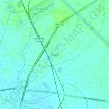
Name: Topografische Karte Khoraj, Höhe, Relief.
Durchschnittliche Höhe: 63 m
Minimale Höhe: 59 m
Maximale Höhe: 70 m
Andere topografische Karten
Klicken Sie auf eine Karte, um ihre Topografie, ihre Höhe und ihr Relief anzuzeigen.
Gandhinagar
India > Gujarat > Gandhinagar Taluka
Gandhinagar has an average elevation of 81 metres (266 feet). The city sits on the banks of the Sabarmati River, in north-central-east Gujarat. The 20,543 km2 area around Gandhinagar is defined by Gujarat capital territory. Gandhinagar spans an area of 326 km2 (126 sq mi). The river frequently dries up in the…
Durchschnittliche Höhe: 75 m
Gujarat International Finance Tec-City
India > Gujarat > Gandhinagar Taluka
Durchschnittliche Höhe: 66 m
Gandhinagar
India > Gujarat > Gandhinagar Taluka
Gandhinagar has an average elevation of 81 metres (266 feet). The city sits on the banks of the Sabarmati River, in north-central-east Gujarat. The 20,543 km2 area around Gandhinagar is defined by Gujarat capital territory. Gandhinagar spans an area of 326 km2 (126 sq mi). The river frequently dries up in the…
Durchschnittliche Höhe: 75 m