
Topografische Karte Westmoreland
Interaktive Karte
Klicken Sie auf die Karte, um die Höhe anzuzeigen.
Über diese Karte
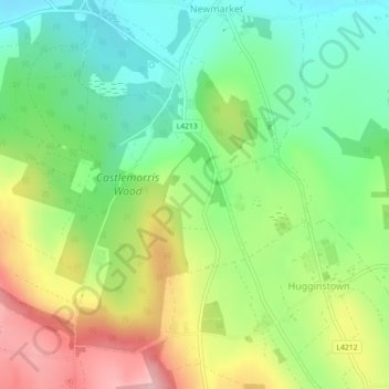
Name: Topografische Karte Westmoreland, Höhe, Relief.
Durchschnittliche Höhe: 134 m
Minimale Höhe: 63 m
Maximale Höhe: 240 m
Andere topografische Karten
Klicken Sie auf eine Karte, um ihre Topografie, ihre Höhe und ihr Relief anzuzeigen.
Clomantagh (Mt Garrett)
Clomantagh (Mt Garrett), Clomantagh, The Municipal District of Castlecomer, Comté de Kilkenny, Leinster, Irlande
Durchschnittliche Höhe: 217 m
Agha
Agha, Rathcoole, The Municipal District of Castlecomer, Comté de Kilkenny, Leinster, Irlande
Durchschnittliche Höhe: 213 m
Tifeaghna (Mt Garrett)
Tifeaghna (Mt Garrett), Lisdowney, The Municipal District of Castlecomer, Comté de Kilkenny, Leinster, Irlande
Durchschnittliche Höhe: 145 m
The Municipal District of Kilkenny City
The Municipal District of Kilkenny City, Comté de Kilkenny, Leinster, Irlande
Durchschnittliche Höhe: 84 m
Kilkenny
Kilkenny, Comté de Kilkenny, Leinster, Irlande
Durchschnittliche Höhe: 62 m