Geolokalisieren
👉 Easily get elevation data in JSON, GeoTIFF and KML formats using Elevation API
Vielen Dank für die Unterstützung dieser Website ❤️
Spenden

Topografische Karte Milam Glacier

Klicken Sie auf die Karte, um die Höhe anzuzeigen.

👉 Easily get elevation data in JSON, GeoTIFF and KML formats using Elevation API
Vielen Dank für die Unterstützung dieser Website ❤️
Spenden

Milam Glacier

The Bhotiya communities living in the Pithoragarh district historically practised transhumance between summer villages located at higher altitudes, close to the border with Tibet, and winter settlements located at lower altitudes, close to the Himalayan foothills and the Gangetic plains. With transhumance as a base, many of them would engage in annual trade visits to market towns such as Taklakot in western Tibet, and some would practice nomadic pastoralism as well. This way of life came to an abrupt end in the 1962 due to the Sino-Indian War. Trans-Himalayan trade was allowed again since the under 1990s. But unlike in the past, it was now to be conducted under state-imposed regulations and limitations, and was allowed only across the Pithoragarh district's Lipu Lekh pass, whereas in earlier times, in Kumaon and Garwhal, the Trans-Himalayan trade had been conducted across several passes.

Wikipedia (CC-BY-SA 3.0)

👉 Easily get elevation data in JSON, GeoTIFF and KML formats using Elevation API
Vielen Dank für die Unterstützung dieser Website ❤️
Spenden

Über diese Karte

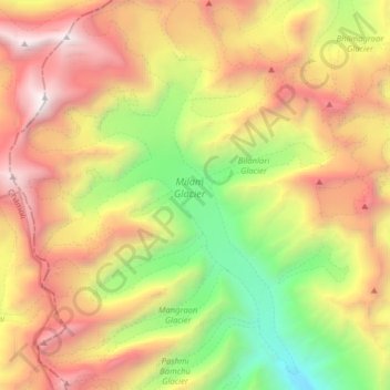
Name: Topografische Karte Milam Glacier, Höhe, Relief.

Ort: Milam Glacier, Munsiari tehsil, Pithoragarh district, Uttarakhand, India (30.46361 80.00447 30.59488 80.11405)

Durchschnittliche Höhe: 5.229 m

Minimale Höhe: 3.582 m

Maximale Höhe: 7.111 m

👉 Easily get elevation data in JSON, GeoTIFF and KML formats using Elevation API
Vielen Dank für die Unterstützung dieser Website ❤️
Spenden

Andere topografische Karten

Klicken Sie auf eine Karte, um ihre Topografie, ihre Höhe und ihr Relief anzuzeigen.

Munsyari

India > Uttarakhand > Munsiari tehsil

Durchschnittliche Höhe: 2.306 m

Ranti

India > Uttarakhand > Munsiari tehsil > Garghaniya

Durchschnittliche Höhe: 1.889 m

Namik

India > Uttarakhand > Munsiari tehsil

Durchschnittliche Höhe: 2.370 m

Munsyari

India > Uttarakhand > Munsiari tehsil

Durchschnittliche Höhe: 2.306 m

Vielen Dank für die Unterstützung dieser Website ❤️
Spenden

Munsyari

India > Uttarakhand > Munsiari tehsil

Durchschnittliche Höhe: 2.306 m

Namik

India > Uttarakhand > Munsiari tehsil

Durchschnittliche Höhe: 2.370 m

Munsyari

India > Uttarakhand > Munsiari tehsil

Durchschnittliche Höhe: 2.306 m