
Topografische Karte Kibalabag
Klicken Sie auf die Karte, um die Höhe anzuzeigen.
Über diese Karte
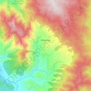
Name: Topografische Karte Kibalabag, Höhe, Relief.
Durchschnittliche Höhe: 1.248 m
Minimale Höhe: 609 m
Maximale Höhe: 1.868 m
Andere topografische Karten
Klicken Sie auf eine Karte, um ihre Topografie, ihre Höhe und ihr Relief anzuzeigen.
Mount Kitanglad Range Natural Park
Philippines > Bukidnon > Malaybalay
Durchschnittliche Höhe: 1.173 m
Mount Dulang-Dulang
Philippines > Bukidnon > Malaybalay
Mount Dulang-dulang, dubbed by Filipino mountaineers as "D2" and also known as Mount Katanglad, is the highest elevation peak in the Kitanglad Mountain Range, located in the north central portion of the province of Bukidnon in the island of Mindanao. It is the second highest mountain of the Philippines at…
Durchschnittliche Höhe: 2.458 m