
Spenden
Topografische Karte Sugar Camp
Klicken Sie auf die Karte, um die Höhe anzuzeigen.
Spenden
Über diese Karte
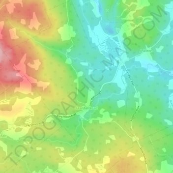
Name: Topografische Karte Sugar Camp, Höhe, Relief.
Durchschnittliche Höhe: 68 m
Minimale Höhe: 4 m
Maximale Höhe: 159 m
Spenden
Andere topografische Karten
Klicken Sie auf eine Karte, um ihre Topografie, ihre Höhe und ihr Relief anzuzeigen.
Long Point Provincial Park
Canada > Nova Scotia > Municipality of the County of Inverness > Long Point
Durchschnittliche Höhe: 32 m
Upper Glencoe
Canada > Nova Scotia > Municipality of the County of Inverness > Glencoe
Durchschnittliche Höhe: 181 m
Meat Cove
Canada > Nova Scotia > Municipality of the County of Inverness > Meat Cove
Durchschnittliche Höhe: 117 m
Hawleys Hill
Canada > Nova Scotia > Municipality of the County of Inverness > Mabou
Durchschnittliche Höhe: 90 m
Spenden
Mount Young
Canada > Nova Scotia > Municipality of the County of Inverness > Hays River
Durchschnittliche Höhe: 185 m