Topografische Karte Distrikt Mokhotlong
Interaktive Karte
Klicken Sie auf die Karte, um die Höhe anzuzeigen.
Über diese Karte
![Topografische Karte Distrikt Mokhotlong, Höhe, Relief](/pub/maps/relation/7ztf/pzdcmt/thumbnail.jpg)
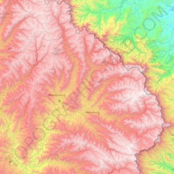
Name: Topografische Karte Distrikt Mokhotlong, Höhe, Relief.
Ort: Distrikt Mokhotlong, Lesotho (-29.58166 28.55597 -28.75596 29.45571)
Durchschnittliche Höhe: 2.435 m
Minimale Höhe: 1.029 m
Maximale Höhe: 3.463 m
Andere topografische Karten
Klicken Sie auf eine Karte, um ihre Topografie, ihre Höhe und ihr Relief anzuzeigen.
![Topografische Karte Mafadi, Höhe, Relief](/pub/maps/node/2kcz/vqks38rr/icon.jpg)
Mafadi
Mafadi, Distrikt Mokhotlong, Lesotho
Durchschnittliche Höhe: 3.285 m
![Topografische Karte Thabana Ntlenyana, Höhe, Relief](/pub/maps/node/ft9m/7xdp5wtf/icon.jpg)
Thabana Ntlenyana
Thabana Ntlenyana, Distrikt Mokhotlong, Lesotho
Durchschnittliche Höhe: 3.313 m
![Topografische Karte Sehlabathebe National Park, Höhe, Relief](/pub/maps/relation/1nx/9rqzf3/icon.jpg)
Sehlabathebe National Park
Lesotho > Qacha's Nek District
Sehlabathebe National Park, Qacha's Nek District, Lesotho
Durchschnittliche Höhe: 2.331 m