
Spenden
Topografische Karte La Mesa Dam
Klicken Sie auf die Karte, um die Höhe anzuzeigen.
Spenden
La Mesa Dam
The La Mesa was built in Novaliches, which was then still part of the municipality of Caloocan due to the sloping topography of the watershed area from Bulacan. The La Mesa dam later became part of a larger dam system with the opening of the Ipo Dam in Norzagaray, Bulacan in 1936, the Angat Dam in the same locale in 1967. The three dams formed part of the Angat-Ipo-La Mesa water system.
Spenden
Über diese Karte
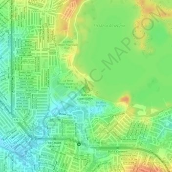
Name: Topografische Karte La Mesa Dam, Höhe, Relief.
Durchschnittliche Höhe: 65 m
Minimale Höhe: 44 m
Maximale Höhe: 88 m
Spenden
Andere topografische Karten
Klicken Sie auf eine Karte, um ihre Topografie, ihre Höhe und ihr Relief anzuzeigen.
Spenden
Spenden
Spenden
Spenden
La Mesa Eco Park
Covering an area of 33 hectares (82 acres) the public park is located along the natural boundary of the La Mesa Watershed Reservation and its elevation is about 40 metres (130 ft) below than the reservoir.
Durchschnittliche Höhe: 66 m
Spenden
Spenden
Spenden
Spenden
Spenden
Spenden
Spenden
Spenden
Spenden
Spenden
Spenden
La Mesa Watershed Reservation
The highest elevation in Quezon City is in the watershed's northern tip at 250 meters (820 ft) above sea level. It centers on the 700-hectare (1,700-acre) La Mesa Dam and Reservoir in Novaliches, an artificial lake which was created in 1929 as part of Manila's Ipo–Novaliches–San Juan water system under the…
Durchschnittliche Höhe: 90 m
Spenden
Spenden
Spenden
Spenden
Spenden
Spenden
La Mesa Eco Park
Covering an area of 33 hectares (82 acres) the public park is located along the natural boundary of the La Mesa Watershed Reservation and its elevation is about 40 metres (130 ft) below than the reservoir.
Durchschnittliche Höhe: 66 m
Spenden
Spenden
Spenden
La Mesa Eco Park
Covering an area of 33 hectares (82 acres) the public park is located along the natural boundary of the La Mesa Watershed Reservation and its elevation is about 40 metres (130 ft) below than the reservoir.
Durchschnittliche Höhe: 66 m
Spenden