Geolokalisieren

Topografische Karte Kersimonou

Interaktive Karte

Klicken Sie auf die Karte, um die Höhe anzuzeigen.

Über diese Karte

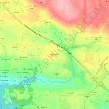
Name: Topografische Karte Kersimonou, Höhe, Relief.

Ort: Kersimonou, Concarneau, Quimper, Finistère, Bretagne, France métropolitaine, 29900, France (47.91589 -3.94014 47.95589 -3.90014)

Durchschnittliche Höhe: 89 m

Minimale Höhe: 19 m

Maximale Höhe: 155 m

Andere topografische Karten

Klicken Sie auf eine Karte, um ihre Topografie, ihre Höhe und ihr Relief anzuzeigen.

Landan Creis

France > Bretagne > Finistère > Concarneau

Landan Creis, Concarneau, Quimper, Finistère, Bretagne, France métropolitaine, 29900, France

Durchschnittliche Höhe: 24 m

La Maison Blanche

France > Bretagne > Finistère > Concarneau > Le Zins

La Maison Blanche, Le Zins, Concarneau, Quimper, Finistère, Bretagne, France métropolitaine, 29900, France

Durchschnittliche Höhe: 44 m

Kercorre

France > Bretagne > Finistère > Concarneau

Kercorre, Concarneau, Quimper, Finistère, Bretagne, France métropolitaine, 29900, France

Durchschnittliche Höhe: 28 m

Le Dorlett

France > Bretagne > Finistère > Concarneau

Le Dorlett, Concarneau, Quimper, Finistère, Bretagne, France métropolitaine, 29900, France

Durchschnittliche Höhe: 30 m

Kerangall

France > Bretagne > Finistère > Concarneau

Kerangall, Concarneau, Quimper, Finistère, Bretagne, France métropolitaine, 29900, France

Durchschnittliche Höhe: 12 m

Toulmengleuz

France > Bretagne > Finistère > Concarneau

Toulmengleuz, Concarneau, Quimper, Finistère, Bretagne, France métropolitaine, 29900, France

Durchschnittliche Höhe: 28 m

Le Mine

France > Bretagne > Finistère > Concarneau

Le Mine, Concarneau, Quimper, Finistère, Bretagne, France métropolitaine, 29900, France

Durchschnittliche Höhe: 12 m

Stang Couls

France > Bretagne > Finistère > Concarneau

Stang Couls, Concarneau, Quimper, Finistère, Bretagne, France métropolitaine, 29900, France

Durchschnittliche Höhe: 53 m

Le Cabellou

France > Bretagne > Finistère > Concarneau > Le Cabellou

Le Cabellou, Concarneau, Quimper, Finistère, Bretagne, France métropolitaine, 29900, France

Durchschnittliche Höhe: 7 m

Les Hauts du Cabelou

France > Bretagne > Finistère > Concarneau > Les Hauts du Cabelou

Les Hauts du Cabelou, Concarneau, Quimper, Finistère, Bretagne, France métropolitaine, 29900, France

Durchschnittliche Höhe: 16 m

Coat Pin

France > Bretagne > Finistère > Concarneau

Coat Pin, Concarneau, Quimper, Finistère, Bretagne, France métropolitaine, 29900, France

Durchschnittliche Höhe: 12 m

La Villeneuve

France > Bretagne > Finistère > Concarneau

La Villeneuve, Concarneau, Quimper, Finistère, Bretagne, France métropolitaine, 29900, France

Durchschnittliche Höhe: 50 m

Lanadan Creiz

France > Bretagne > Finistère > Concarneau

Lanadan Creiz, Concarneau, Quimper, Finistère, Bretagne, France métropolitaine, 29900, France

Durchschnittliche Höhe: 32 m

Le Rouz

France > Bretagne > Finistère > Concarneau

Le Rouz, Concarneau, Quimper, Finistère, Bretagne, France métropolitaine, 29900, France

Durchschnittliche Höhe: 17 m

Stang Noblet

France > Bretagne > Finistère > Concarneau

Stang Noblet, Concarneau, Quimper, Finistère, Bretagne, France métropolitaine, 29900, France

Durchschnittliche Höhe: 41 m

Le Zins

France > Bretagne > Finistère > Concarneau

Le Zins, Concarneau, Quimper, Finistère, Bretagne, France métropolitaine, 29900, France

Durchschnittliche Höhe: 47 m