
Topografische Karte Pictou Island
Interaktive Karte
Klicken Sie auf die Karte, um die Höhe anzuzeigen.
Über diese Karte
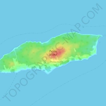
Name: Topografische Karte Pictou Island, Höhe, Relief.
Durchschnittliche Höhe: 4 m
Minimale Höhe: 0 m
Maximale Höhe: 49 m
Pictou Island is a Canadian island located in the Northumberland Strait approximately 4 NM north of Nova Scotia and 10 NM south of Prince Edward Island. Measuring 9.5 km in length and 2.5 km in width, the total area is 23.75 km2. The island is administratively part of Pictou County. The island's highest elevation is 24 meters (78 feet) above sea level, and its current full-time residents population (as of 2016) stands at 28, with the seasonal population rising and lowering.