
Spenden
Topografische Karte Cadillac Mountain
Klicken Sie auf die Karte, um die Höhe anzuzeigen.
Spenden
Cadillac Mountain
Cadillac Mountain is located on Mount Desert Island, within Acadia National Park, in the U.S. state of Maine. With an elevation of 1,530 feet (470 meters), its summit is the highest point in Hancock County and the highest within 25 miles (40 km) of the Atlantic shoreline of the North American continent between the Cape Breton Highlands, Nova Scotia, and peaks in Mexico. It is known as the first place in the continental U.S. to see the sunrise, although that is only true for a portion of the year.
Spenden
Über diese Karte
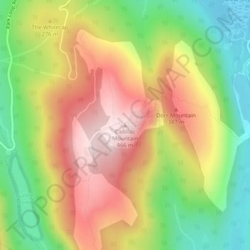
Name: Topografische Karte Cadillac Mountain, Höhe, Relief.
Durchschnittliche Höhe: 233 m
Minimale Höhe: 15 m
Maximale Höhe: 461 m
Spenden
Andere topografische Karten
Klicken Sie auf eine Karte, um ihre Topografie, ihre Höhe und ihr Relief anzuzeigen.
Acadia National Park
United States > Maine > Hancock County > Bar Harbor
The ecological zones at Acadia National Park, from highest to lowest elevation, include: nearly barren mountain summits; northern boreal and eastern deciduous forests on the mountainsides; freshwater lakes and ponds, as well as wetlands like marshes and swamps in the valleys between mountains; and the Atlantic…
Durchschnittliche Höhe: 9 m
Spenden