
Vielen Dank für die Unterstützung dieser Website ❤️
Spenden
Spenden
Topografische Karte Old Brampton
Klicken Sie auf die Karte, um die Höhe anzuzeigen.
Vielen Dank für die Unterstützung dieser Website ❤️
Spenden
Spenden
Über diese Karte
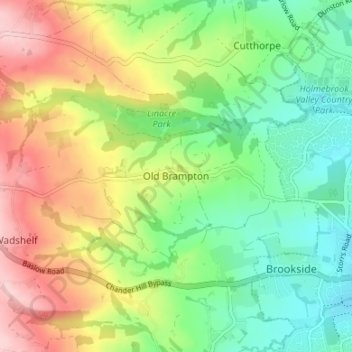
Name: Topografische Karte Old Brampton, Höhe, Relief.
Durchschnittliche Höhe: 181 m
Minimale Höhe: 100 m
Maximale Höhe: 301 m
Vielen Dank für die Unterstützung dieser Website ❤️
Spenden
Spenden
Andere topografische Karten
Klicken Sie auf eine Karte, um ihre Topografie, ihre Höhe und ihr Relief anzuzeigen.
Ashover CP
United Kingdom > England > Derbyshire > North East Derbyshire
By the 18th century, there were several thousand acres of unenclosed moorland in the parish of Ashover, principally covered with heath. The only paths across this wilderness for roads were tracks in the sand or heath with here and there a stone post on the hills or elevations to serve as guides to the…
Durchschnittliche Höhe: 210 m
Clay Cross CP
United Kingdom > England > Derbyshire > North East Derbyshire
Durchschnittliche Höhe: 133 m
Vielen Dank für die Unterstützung dieser Website ❤️
Spenden
Spenden