
Spenden
Topografische Karte Salvador
Klicken Sie auf die Karte, um die Höhe anzuzeigen.
Spenden
Salvador
Centralization as a capital, along with Portuguese colonization, were important factors in shaping the profile of the municipality, as were certain geographic characteristics. The construction of the city followed the uneven topography, initially with the formation of two levels—Upper Town (Cidade Alta) and Lower Town (Cidade Baixa)—on a steep escarpment, and later with the conception of valley avenues. With 692,818 square kilometers (267,499 sq mi) in area, its emerged territory is peninsular, and the coast is bordered by the Bay of All Saints to the west and the Atlantic Ocean to the east. The Historic Center of Salvador, iconized on the outskirts of Pelourinho, is known for its colonial architecture, with historical monuments dating from the 17th century to the beginning of the 20th century, and was declared a World Heritage Site by UNESCO in 1985. The stage of one of the biggest Carnivals in the world (the biggest street party in the world, according to the Guinness World Records), the integration of the municipality to the UNESCO's Creative Cities Network as the "City of Music", a unique title in the country, added to the international recognition of Salvador's music.
Spenden
Über diese Karte
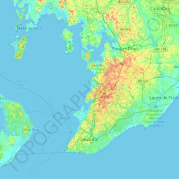
Name: Topografische Karte Salvador, Höhe, Relief.
Durchschnittliche Höhe: 19 m
Minimale Höhe: -8 m
Maximale Höhe: 144 m
Spenden
Andere topografische Karten
Klicken Sie auf eine Karte, um ihre Topografie, ihre Höhe und ihr Relief anzuzeigen.
Costa do Sauípe
Brazil > Bahia > Região Metropolitana de Salvador > Mata de São João
Durchschnittliche Höhe: 10 m
Praia do Forte
Brazil > Bahia > Região Metropolitana de Salvador > Mata de São João
Durchschnittliche Höhe: 5 m