
Topografische Karte Alexander
Interaktive Karte
Klicken Sie auf die Karte, um die Höhe anzuzeigen.
Über diese Karte
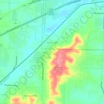
Name: Topografische Karte Alexander, Höhe, Relief.
Ort: Alexander, Pulaski County, Arkansas, United States (34.60514 -92.47235 34.64631 -92.43800)
Durchschnittliche Höhe: 115 m
Minimale Höhe: 86 m
Maximale Höhe: 178 m
Andere topografische Karten
Klicken Sie auf eine Karte, um ihre Topografie, ihre Höhe und ihr Relief anzuzeigen.
Little Rock
United States > Arkansas > Pulaski County
Little Rock, Pulaski County, Arkansas, United States
Durchschnittliche Höhe: 96 m
Pecan Grove
United States > Arkansas > Pulaski County > North Little Rock
Pecan Grove, North Little Rock, Pulaski County, Arkansas, 72117, United States
Durchschnittliche Höhe: 80 m
Maumelle
United States > Arkansas > Pulaski County
Maumelle, Pulaski County, Arkansas, 72113, United States
Durchschnittliche Höhe: 87 m
Landmark
United States > Arkansas > Pulaski County
Landmark, Pulaski County, Arkansas, United States
Durchschnittliche Höhe: 109 m
Pinnacle Mountain State Park
United States > Arkansas > Pulaski County
Pinnacle Mountain State Park, Pulaski County, Arkansas, 72135, United States
Durchschnittliche Höhe: 96 m
Mabelvale
United States > Arkansas > Pulaski County > Little Rock
Mabelvale, Little Rock, Pulaski County, Arkansas, 72209, United States
Durchschnittliche Höhe: 98 m
Douglasville
United States > Arkansas > Pulaski County > Little Rock
Douglasville, Little Rock, Pulaski County, Arkansas, 72204, United States
Durchschnittliche Höhe: 98 m
Ferndale
United States > Arkansas > Pulaski County
Ferndale, Pulaski County, Arkansas, United States
Durchschnittliche Höhe: 148 m
Little Rock
United States > Arkansas > Pulaski County > Little Rock
Little Rock, Pulaski County, Arkansas, 72201, United States
Durchschnittliche Höhe: 98 m
Roland
United States > Arkansas > Pulaski County
Roland, Pulaski County, Arkansas, 72135, United States
Durchschnittliche Höhe: 89 m
Parkway Place
United States > Arkansas > Pulaski County > Little Rock
Parkway Place, Little Rock, Pulaski County, Arkansas, 72211, United States
Durchschnittliche Höhe: 153 m
Cammack Village
United States > Arkansas > Pulaski County
Cammack Village, Pulaski County, Arkansas, United States
Durchschnittliche Höhe: 135 m
Two Rivers Park
United States > Arkansas > Pulaski County > Little Rock > Overlook Park
Two Rivers Park, Overlook Park, Little Rock, Pulaski County, Arkansas, United States
Durchschnittliche Höhe: 111 m
Merrivale
United States > Arkansas > Pulaski County > Little Rock > Merrivale
Merrivale, Little Rock, Pulaski County, Arkansas, 72209, United States
Durchschnittliche Höhe: 91 m
North Little Rock
United States > Arkansas > Pulaski County
North Little Rock, Pulaski County, Arkansas, United States
Durchschnittliche Höhe: 96 m
Sherwood
United States > Arkansas > Pulaski County
Sherwood, Pulaski County, Arkansas, 72120, United States
Durchschnittliche Höhe: 108 m
Overlook Park
United States > Arkansas > Pulaski County > Little Rock > Overlook Park
Overlook Park, Little Rock, Pulaski County, Arkansas, 72227, United States
Durchschnittliche Höhe: 122 m
Jacksonville
United States > Arkansas > Pulaski County
Jacksonville, Pulaski County, Arkansas, United States
Durchschnittliche Höhe: 84 m