
Topografische Karte Orechová Potôň
Interaktive Karte
Klicken Sie auf die Karte, um die Höhe anzuzeigen.
Über diese Karte
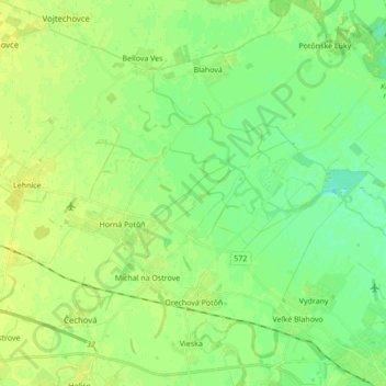
Name: Topografische Karte Orechová Potôň, Höhe, Relief.
Durchschnittliche Höhe: 118 m
Minimale Höhe: 110 m
Maximale Höhe: 124 m
The municipality lies at an altitude of 120 metres and covers an area of 21.069 km². It has a population of about 1,732 people. According to the census of 2001, the village had a population of 1,671, from which 1,573 were Hungarians and 99 Slovaks.
Andere topografische Karten
Klicken Sie auf eine Karte, um ihre Topografie, ihre Höhe und ihr Relief anzuzeigen.
Danube
Slovakia > Region of Trnava > District of Dunajská Streda
Danube, District of Dunajská Streda, Region of Trnava, Western Slovakia, Slovakia
Durchschnittliche Höhe: 119 m
Jahodná
Slovakia > Region of Trnava > District of Dunajská Streda
Jahodná, District of Dunajská Streda, Region of Trnava, Western Slovakia, 930 21, Slovakia
Durchschnittliche Höhe: 114 m
Trhová Hradská
Slovakia > Region of Trnava > District of Dunajská Streda
Trhová Hradská, District of Dunajská Streda, Region of Trnava, Western Slovakia, Slovakia
Durchschnittliche Höhe: 113 m
Gabčíkovo
Slovakia > Region of Trnava > District of Dunajská Streda
Gabčíkovo, District of Dunajská Streda, Region of Trnava, Western Slovakia, 930 05, Slovakia
Durchschnittliche Höhe: 114 m
Dunajská Streda
Slovakia > Region of Trnava > District of Dunajská Streda
Dunajská Streda, District of Dunajská Streda, Region of Trnava, Western Slovakia, 929 01, Slovakia
Durchschnittliche Höhe: 115 m