
Topografische Karte Holywood
Interaktive Karte
Klicken Sie auf die Karte, um die Höhe anzuzeigen.
Über diese Karte
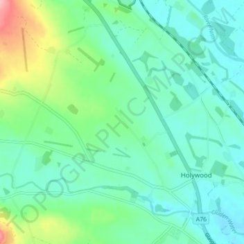
Name: Topografische Karte Holywood, Höhe, Relief.
Durchschnittliche Höhe: 26 m
Minimale Höhe: 7 m
Maximale Höhe: 62 m
Andere topografische Karten
Klicken Sie auf eine Karte, um ihre Topografie, ihre Höhe und ihr Relief anzuzeigen.
Sanquhar
United Kingdom > Scotland > Dumfries and Galloway
Sanquhar, Dumfries and Galloway, Scotland, DG4 6DJ, United Kingdom
Durchschnittliche Höhe: 243 m
Gillesbie
United Kingdom > Scotland > Dumfries and Galloway > Boreland
Gillesbie, Boreland, Dumfries and Galloway, Scotland, DG11 2LF, United Kingdom
Durchschnittliche Höhe: 195 m
Lockerbie
United Kingdom > Scotland > Dumfries and Galloway
Lockerbie, Dumfries and Galloway, Scotland, DG11 2EU, United Kingdom
Durchschnittliche Höhe: 96 m
Ley Hill
United Kingdom > Scotland > Dumfries and Galloway
Ley Hill, Dumfries and Galloway, Scotland, DG11 3HG, United Kingdom
Durchschnittliche Höhe: 214 m
Cairnryan
United Kingdom > Scotland > Dumfries and Galloway > Cairnryan
Cairnryan, Dumfries and Galloway, Scotland, DG9 8RB, United Kingdom
Durchschnittliche Höhe: 64 m
Drummore
United Kingdom > Scotland > Dumfries and Galloway
Drummore, Dumfries and Galloway, Scotland, DG9 9PY, United Kingdom
Durchschnittliche Höhe: 36 m