
Topografische Karte New Ross
Interaktive Karte
Klicken Sie auf die Karte, um die Höhe anzuzeigen.
Über diese Karte
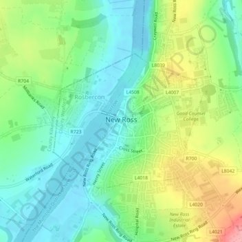
Name: Topografische Karte New Ross, Höhe, Relief.
Ort: New Ross, Comté de Wexford, Leinster, Irlande (52.38788 -6.95701 52.40294 -6.92830)
Durchschnittliche Höhe: 39 m
Minimale Höhe: -9 m
Maximale Höhe: 115 m
Andere topografische Karten
Klicken Sie auf eine Karte, um ihre Topografie, ihre Höhe und ihr Relief anzuzeigen.
The Municipal District of Enniscorthy
The Municipal District of Enniscorthy, Comté de Wexford, Leinster, Irlande
Durchschnittliche Höhe: 108 m
Saint Vogue's
Saint Vogue's, Lady's Island ED, The Borough District of Wexford, Comté de Wexford, Leinster, Irlande
Durchschnittliche Höhe: 3 m
The Borough District of Wexford
The Borough District of Wexford, Comté de Wexford, Leinster, Irlande
Durchschnittliche Höhe: 29 m
Bellary
Bellary, Duncormick ED, The Borough District of Wexford, Comté de Wexford, Leinster, Irlande
Durchschnittliche Höhe: 13 m
Gorey
Gorey Corporation Townlands, Gorey, The Municipal District of Gorey — Kilmuckridge, Comté de Wexford, Leinster, Irlande
Durchschnittliche Höhe: 60 m