
Topografische Karte Basehor
Interaktive Karte
Klicken Sie auf die Karte, um die Höhe anzuzeigen.
Über diese Karte
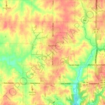
Name: Topografische Karte Basehor, Höhe, Relief.
Ort: Basehor, Leavenworth County, Kansas, 66007, United States (39.10171 -94.97354 39.17237 -94.90056)
Durchschnittliche Höhe: 286 m
Minimale Höhe: 250 m
Maximale Höhe: 308 m
Andere topografische Karten
Klicken Sie auf eine Karte, um ihre Topografie, ihre Höhe und ihr Relief anzuzeigen.
Maywood
United States > Kansas > Leavenworth County > Leavenworth
Maywood, Leavenworth, Leavenworth County, Kansas, 64092, United States
Durchschnittliche Höhe: 246 m
Fairmount
United States > Kansas > Leavenworth County
Fairmount, Leavenworth County, Kansas, United States
Durchschnittliche Höhe: 290 m
Leavenworth
United States > Kansas > Leavenworth County
Leavenworth, Leavenworth County, Kansas, United States
Durchschnittliche Höhe: 268 m
Linwood
United States > Kansas > Leavenworth County
Linwood, Leavenworth County, Kansas, United States
Durchschnittliche Höhe: 248 m
Hoge
United States > Kansas > Leavenworth County
Hoge, Leavenworth County, Kansas, United States
Durchschnittliche Höhe: 276 m
Fort Leavenworth
United States > Kansas > Leavenworth County > Leavenworth > Leavenworth
Fort Leavenworth, Leavenworth, Leavenworth County, Kansas, 66027, United States
Durchschnittliche Höhe: 252 m
Lansing
United States > Kansas > Leavenworth County
Lansing, Leavenworth County, Kansas, 66043, United States
Durchschnittliche Höhe: 266 m
Leavenworth
United States > Kansas > Leavenworth County > Leavenworth
Leavenworth, Leavenworth County, Kansas, 66048, United States
Durchschnittliche Höhe: 277 m