
Spenden
Topografische Karte Silsby Lake
Klicken Sie auf die Karte, um die Höhe anzuzeigen.
Spenden
Über diese Karte
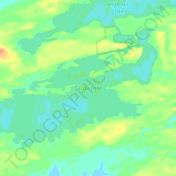
Name: Topografische Karte Silsby Lake, Höhe, Relief.
Ort: Silsby Lake, Manitoba, Canada (55.44388 -95.90775 55.54203 -95.65589)
Durchschnittliche Höhe: 199 m
Minimale Höhe: 192 m
Maximale Höhe: 220 m
Spenden
Andere topografische Karten
Klicken Sie auf eine Karte, um ihre Topografie, ihre Höhe und ihr Relief anzuzeigen.
Pinawa
Canada > Manitoba > Division No. 1 > Local Government District of Pinawa
Durchschnittliche Höhe: 277 m
Spenden
Franklin
Canada > Manitoba > Division No. 15 > Rural Municipality of Rosedale
Durchschnittliche Höhe: 487 m
Spenden
Arden
Canada > Manitoba > Division No. 8 > Municipality of Glenella – Lansdowne
Durchschnittliche Höhe: 327 m
Turtle Mountain Provincial Park
Canada > Manitoba > Municipality of Boissevain-Morton
Durchschnittliche Höhe: 662 m
Spenden
Oak Bluff
Canada > Manitoba > Division No. 10 > Rural Municipality of Macdonald
Durchschnittliche Höhe: 238 m
Silverton
Canada > Manitoba > Division No. 16 > Rural Municipality of Riding Mountain West
Durchschnittliche Höhe: 575 m
Sunset Beach
Canada > Manitoba > Division No. 13 > Rural Municipality of St. Clements
Durchschnittliche Höhe: 223 m
Spenden
Bristol
Canada > Manitoba > Division No. 2 > Rural Municipality of Hanover
Durchschnittliche Höhe: 271 m
Garson
Canada > Manitoba > Division No. 12 > Rural Municipality of Brokenhead
Durchschnittliche Höhe: 242 m
Spenden
Ile des Chenes
Canada > Manitoba > Division No. 2 > Rural Municipality of Ritchot
Durchschnittliche Höhe: 236 m
Winnipeg
Canada > Manitoba > Winnipeg > Winnipeg
Winnipeg lies at the bottom of the Red River Valley, a flood plain with an extremely flat topography. It is on the eastern edge of the Canadian Prairies in Western Canada and is known as the "Gateway to the West". Winnipeg is bordered by tallgrass prairie to the west and south and the aspen parkland to the…
Durchschnittliche Höhe: 236 m
Spenden
Spenden
Darwin
Canada > Manitoba > Division No. 1 > Rural Municipality of Whitemouth
Durchschnittliche Höhe: 293 m
Spenden
Oak Lake Beach
Canada > Manitoba > Division No. 6 > Rural Municipality of Sifton
Durchschnittliche Höhe: 429 m
Butler
Canada > Manitoba > Division No. 6 > Rural Municipality of Wallace – Woodworth
Durchschnittliche Höhe: 524 m
Lenore
Canada > Manitoba > Division No. 6 > Rural Municipality of Wallace – Woodworth
Durchschnittliche Höhe: 460 m
Spenden