
Topografische Karte Kereru
Interaktive Karte
Klicken Sie auf die Karte, um die Höhe anzuzeigen.
Über diese Karte
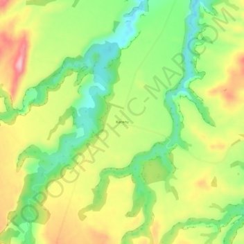
Name: Topografische Karte Kereru, Höhe, Relief.
Ort: Kereru, Hastings District, Hawke's Bay, New Zealand (-39.65582 176.40228 -39.61582 176.44228)
Durchschnittliche Höhe: 305 m
Minimale Höhe: 215 m
Maximale Höhe: 413 m
Andere topografische Karten
Klicken Sie auf eine Karte, um ihre Topografie, ihre Höhe und ihr Relief anzuzeigen.
Hastings
New Zealand > Hawke's Bay > Hastings District
Hastings, Hastings District, Hawke's Bay, 4122, New Zealand
Durchschnittliche Höhe: 68 m
Te Haroto
New Zealand > Hawke's Bay > Hastings District
Te Haroto, Hastings District, Hawke's Bay, New Zealand
Durchschnittliche Höhe: 647 m
Havelock North
New Zealand > Hawke's Bay > Hastings District
Havelock North, Hastings District, Hawke's Bay, 4130, New Zealand
Durchschnittliche Höhe: 45 m
Poukawa
New Zealand > Hawke's Bay > Hastings District
Poukawa, Hastings District, Hawke's Bay, New Zealand
Durchschnittliche Höhe: 49 m
Twyford
New Zealand > Hawke's Bay > Hastings District > Hastings
Twyford, Hastings, Hastings District, Hawke's Bay, 4154, New Zealand
Durchschnittliche Höhe: 19 m
Waikoau
New Zealand > Hawke's Bay > Hastings District
Waikoau, Hastings District, Hawke's Bay, New Zealand
Durchschnittliche Höhe: 290 m
Tutira
New Zealand > Hawke's Bay > Hastings District
Tutira, Hastings District, Hawke's Bay, New Zealand
Durchschnittliche Höhe: 191 m
Mangateretere
New Zealand > Hawke's Bay > Hastings District > Hastings
Mangateretere, Hastings, Hastings District, Hawke's Bay, 4172, New Zealand
Durchschnittliche Höhe: 9 m
Maraekakaho
New Zealand > Hawke's Bay > Hastings District > Maraekakaho
Maraekakaho, Hastings District, Hawke's Bay, New Zealand
Durchschnittliche Höhe: 118 m
Matangi
New Zealand > Hawke's Bay > Hastings District > Hastings
Matangi, Hastings, Hastings District, Hawke's Bay, 4295, New Zealand
Durchschnittliche Höhe: 187 m
Otatara Pā
New Zealand > Hawke's Bay > Hastings District > Napier > Waiohiki
Otatara Pā, Springfield Road, Waiohiki, Napier, Hastings District, Hawke's Bay, 4142, New Zealand
Durchschnittliche Höhe: 31 m
Sherenden
New Zealand > Hawke's Bay > Hastings District > Sherenden
Sherenden, Hastings District, Hawke's Bay, New Zealand
Durchschnittliche Höhe: 258 m
Lake Tutira
New Zealand > Hawke's Bay > Hastings District
Lake Tutira, Hastings District, Hawke's Bay, New Zealand
Durchschnittliche Höhe: 197 m
Crownthorpe
New Zealand > Hawke's Bay > Hastings District
Crownthorpe, Hastings District, Hawke's Bay, New Zealand
Durchschnittliche Höhe: 168 m
Maraetotara River
New Zealand > Hawke's Bay > Hastings District
Maraetotara River, Hastings District, Hawke's Bay, 4180, New Zealand
Durchschnittliche Höhe: 105 m