
Topografische Karte Seligman
Interaktive Karte
Klicken Sie auf die Karte, um die Höhe anzuzeigen.
Über diese Karte
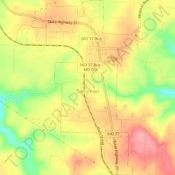
Name: Topografische Karte Seligman, Höhe, Relief.
Ort: Seligman, Barry County, Missouri, United States (36.50638 -93.95108 36.53645 -93.92861)
Durchschnittliche Höhe: 467 m
Minimale Höhe: 410 m
Maximale Höhe: 505 m
Seligman is located in the Ozarks and is, bordered by the Mark Twain National Forest to the east. The town is located on a ridge along Missouri Route 37. Rainfall west of the railroad flows into the Grand Lake o' the Cherokees by way of Big Sugar Creek and Cowskin River. Rainfall to the east of Seligman flows to Table Rock Lake by way of Dry Hollow, Blockade Hollow, and Butler Hollow. The region also hosts Karst topography, characterized by high limestone content and the formation of sinkholes and caves.
Andere topografische Karten
Klicken Sie auf eine Karte, um ihre Topografie, ihre Höhe und ihr Relief anzuzeigen.
Ridgley
United States > Missouri > Barry County
Ridgley, Barry County, Missouri, United States
Durchschnittliche Höhe: 432 m
Madry
United States > Missouri > Barry County
Madry, Barry County, Missouri, United States
Durchschnittliche Höhe: 460 m
Jenkins
United States > Missouri > Barry County
Jenkins, Barry County, Missouri, United States
Durchschnittliche Höhe: 359 m
Pioneer
United States > Missouri > Barry County
Pioneer, Barry County, Missouri, 64842, United States
Durchschnittliche Höhe: 385 m
McDowell
United States > Missouri > Barry County
McDowell, Barry County, Missouri, United States
Durchschnittliche Höhe: 385 m
Eagle Rock
United States > Missouri > Barry County
Eagle Rock, Barry County, Missouri, 65641, United States
Durchschnittliche Höhe: 322 m
Purdy
United States > Missouri > Barry County
Purdy, Barry County, Missouri, 65734, United States
Durchschnittliche Höhe: 445 m
Butterfield
United States > Missouri > Barry County
Butterfield, Barry County, Missouri, 65623, United States
Durchschnittliche Höhe: 463 m
Wheaton
United States > Missouri > Barry County
Wheaton, Barry County, Missouri, United States
Durchschnittliche Höhe: 420 m
Golden
United States > Missouri > Barry County
Golden, Barry County, Missouri, 65658, United States
Durchschnittliche Höhe: 326 m
Exeter
United States > Missouri > Barry County
Exeter, Barry County, Missouri, 65647, United States
Durchschnittliche Höhe: 466 m
Monett
United States > Missouri > Barry County
Monett, Barry County, Missouri, 65708, United States
Durchschnittliche Höhe: 416 m
Roaring River State Park
United States > Missouri > Barry County
Roaring River State Park, Barry County, Missouri, United States
Durchschnittliche Höhe: 372 m
Shell Knob
United States > Missouri > Barry County
Shell Knob, Barry County, Missouri, United States
Durchschnittliche Höhe: 306 m
Reed Mountain
United States > Missouri > Barry County
Reed Mountain, Barry County, Missouri, 65745, United States
Durchschnittliche Höhe: 441 m
Washburn
United States > Missouri > Barry County
Washburn, Barry County, Missouri, United States
Durchschnittliche Höhe: 456 m
Cassville
United States > Missouri > Barry County
Cassville, Barry County, Missouri, United States
Durchschnittliche Höhe: 427 m