
Spenden
Topografische Karte St. John
Klicken Sie auf die Karte, um die Höhe anzuzeigen.
Spenden
St. John
A few hundred metres north of St John village is an area of high ground called Vanderbands, the site of an Iron Age castle mentioned by John Norden (an English topographer who wrote a series of county histories) in his description of Cornwall published in 1728.
Spenden
Über diese Karte
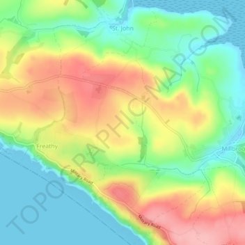
Name: Topografische Karte St. John, Höhe, Relief.
Ort: St. John, Cornwall, England, United Kingdom (50.33576 -4.25673 50.36461 -4.22223)
Durchschnittliche Höhe: 53 m
Minimale Höhe: -2 m
Maximale Höhe: 127 m
Spenden
Andere topografische Karten
Klicken Sie auf eine Karte, um ihre Topografie, ihre Höhe und ihr Relief anzuzeigen.
Spenden
Spenden
Spenden
Bude
United Kingdom > England > Cornwall
Its earlier importance was as a harbour, and then a source of sea sand useful for improving the inland soil. This was transported on the Bude Canal. The Victorians favoured it as a seaside resort. With new rail links, it became a popular seaside destination in the 20th century. Bradshaw's Guide of 1866,…
Durchschnittliche Höhe: 41 m
Spenden
Spenden
Spenden
Spenden
Spenden
Spenden
Spenden
Spenden
Spenden
Spenden
Downgate
United Kingdom > England > Cornwall > Caradon Town > Linkinhorne
Durchschnittliche Höhe: 224 m
Spenden
Spenden
Spenden
Spenden
Spenden
Spenden
Spenden
Spenden
Spenden
Spenden
Spenden
Spenden