
Spenden
Topografische Karte Coulter
Klicken Sie auf die Karte, um die Höhe anzuzeigen.
Spenden
Über diese Karte
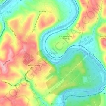
Name: Topografische Karte Coulter, Höhe, Relief.
Durchschnittliche Höhe: 287 m
Minimale Höhe: 219 m
Maximale Höhe: 373 m
Spenden
Andere topografische Karten
Klicken Sie auf eine Karte, um ihre Topografie, ihre Höhe und ihr Relief anzuzeigen.
South Park
United States > Pennsylvania > Allegheny County > South Park Township
Durchschnittliche Höhe: 335 m
South Fayette Township
United States > Pennsylvania > Allegheny County
According to the United States Census Bureau, the township has a total area of 20.4 square miles (53 km2), of which 20.95 square miles (54.3 km2) is land and 0.05% is water. The topography is mostly wooded with small hills and floodplains on four streams. It is located 14 miles (23 km) southwest of Pittsburgh.
Durchschnittliche Höhe: 328 m
Spenden
East Liberty
United States > Pennsylvania > Allegheny County > Pittsburgh
Durchschnittliche Höhe: 289 m
Brackenridge
United States > Pennsylvania > Allegheny County
Brackenridge is located at 40°36′30″N 79°44′32″W / 40.60833°N 79.74222°W / 40.60833; -79.74222. The borough's average elevation is 827 feet (252 m) above sea level. According to the U.S. Census Bureau, the borough has a total area of 0.6 square miles (1.6 km2), of which 0.5 square miles…
Durchschnittliche Höhe: 266 m
Spenden
Spenden
Russellton
United States > Pennsylvania > Allegheny County > West Deer Township
Durchschnittliche Höhe: 325 m
Curtisville
United States > Pennsylvania > Allegheny County > West Deer Township > Curtisville
Durchschnittliche Höhe: 344 m
Spenden
Spenden
Spenden
Spenden
Spenden
Bradford Woods
United States > Pennsylvania > Allegheny County
According to the United States Census Bureau, the borough has a total area of 0.9 square miles (2.3 km2), all of it land. Its average elevation is 1,250 ft (381 m) above sea level.
Durchschnittliche Höhe: 369 m
Avalon
United States > Pennsylvania > Allegheny County
According to the United States Census Bureau, the borough has a total area of 0.7 square miles (1.8 km2), of which 0.6 square miles (1.6 km2) is land and 0.1 square miles (0.26 km2) is water. Its average elevation is 932 feet (284 m) above sea level.
Durchschnittliche Höhe: 275 m
Spenden
Baldwin
United States > Pennsylvania > Allegheny County
According to the U.S. Census Bureau, the borough has a total area of 5.9 square miles (15 km2), of which 5.8 square miles (15 km2) is land and 0.1 square miles (0.26 km2) is water. Its average elevation is 1,214 feet (370 m) above sea level.
Durchschnittliche Höhe: 338 m
Ben Avon
United States > Pennsylvania > Allegheny County
Its average elevation is 928 feet (283 m) above sea level.
Durchschnittliche Höhe: 263 m
Ben Avon Heights
United States > Pennsylvania > Allegheny County
According to the United States Census Bureau, the borough has a total area of 0.2 square miles (0.52 km2), all land. Its average elevation is 1,135 feet (346 m) above sea level.
Durchschnittliche Höhe: 294 m
Spenden
Aspinwall
United States > Pennsylvania > Allegheny County
Aspinwall is located at 40°29′35″N 79°54′11″W / 40.49306°N 79.90306°W / 40.49306; -79.90306. According to the U.S. Census Bureau, the borough has a total area of 0.4 square miles (1.0 km2), of which 0.3 square miles (0.78 km2) is land and 0.04 square miles (0.10 km2) is water. Its average…
Durchschnittliche Höhe: 275 m
Spenden
Blawnox
United States > Pennsylvania > Allegheny County
According to the United States Census Bureau, the borough has a total area of 0.4 square miles (1.0 km2), of which 0.3 square miles (0.78 km2) is land and 0.1 square miles (0.26 km2), or 25.58%, is water. Its average elevation is 843 feet (257 m) above sea level.
Durchschnittliche Höhe: 265 m
Bell Acres
United States > Pennsylvania > Allegheny County
According to the United States Census Bureau, the borough has a total area of 5.2 square miles (13 km2), all land. Its average elevation is 965 feet (294 m) above sea level.
Durchschnittliche Höhe: 316 m
Spenden
Panther Hollow Lake
United States > Pennsylvania > Allegheny County > Pittsburgh
Durchschnittliche Höhe: 286 m
Spenden
Allegheny Islands State Park
United States > Pennsylvania > Allegheny County > Plum > Acmetonia
Durchschnittliche Höhe: 259 m
Spenden
Chartiers City
United States > Pennsylvania > Allegheny County > Pittsburgh
Durchschnittliche Höhe: 259 m
Spenden
Spenden
Castle Shannon
United States > Pennsylvania > Allegheny County
According to the United States Census Bureau, the borough has a total area of 1.6 square miles (4.1 km2), all of it land. Its average elevation is 1,040 feet (320 m) above sea level.
Durchschnittliche Höhe: 354 m
Beechwood Farms
United States > Pennsylvania > Allegheny County > Fox Chapel
Durchschnittliche Höhe: 337 m
Forward Township
United States > Pennsylvania > Allegheny County > Forward Township
Durchschnittliche Höhe: 306 m
Brunot Island
United States > Pennsylvania > Allegheny County > Pittsburgh
Durchschnittliche Höhe: 241 m
Spenden