
Topografische Karte Stokes County
Interaktive Karte
Klicken Sie auf die Karte, um die Höhe anzuzeigen.
Über diese Karte
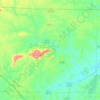
Name: Topografische Karte Stokes County, Höhe, Relief.
Ort: Stokes County, North Carolina, USA (36.25430 -80.45738 36.55063 -80.02727)
Durchschnittliche Höhe: 294 m
Minimale Höhe: 172 m
Maximale Höhe: 756 m
Andere topografische Karten
Klicken Sie auf eine Karte, um ihre Topografie, ihre Höhe und ihr Relief anzuzeigen.
Appalachians
Appalachians, Yancey County, North Carolina, USA
Durchschnittliche Höhe: 1.463 m
Southern Nantahala Wilderness
Southern Nantahala Wilderness, Appalachian Trail, Macon County, North Carolina, USA
Durchschnittliche Höhe: 957 m
Mount Mitchell
Mount Mitchell, Yancey County, North Carolina, USA
Durchschnittliche Höhe: 1.743 m
Chapel Hill
USA > North Carolina > Chapel Hill
Chapel Hill, Orange County, North Carolina, USA
Durchschnittliche Höhe: 125 m
Downs Mountain
Downs Mountain, Macon County, North Carolina, 28763, USA
Durchschnittliche Höhe: 732 m