
Topografische Karte Poços de Caldas
Interaktive Karte
Klicken Sie auf die Karte, um die Höhe anzuzeigen.
Über diese Karte
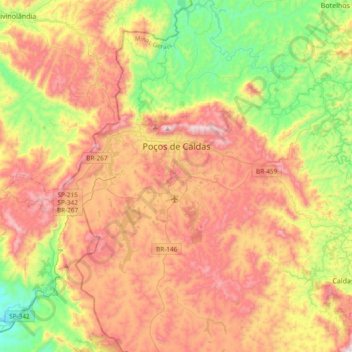
Name: Topografische Karte Poços de Caldas, Höhe, Relief.
Durchschnittliche Höhe: 1.188 m
Minimale Höhe: 754 m
Maximale Höhe: 1.686 m
It lies on the boundary of the state of São Paulo at 1186 meters elevation and is the main socio-economic nucleus of its region, having an area of 547 km² (85 km² urban and 459 km² rural) in the municipality.