
Topografische Karte Bunker Hill
Interaktive Karte
Klicken Sie auf die Karte, um die Höhe anzuzeigen.
Über diese Karte
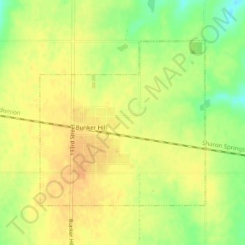
Name: Topografische Karte Bunker Hill, Höhe, Relief.
Ort: Bunker Hill, Russell County, Kansas, United States (38.86724 -98.71125 38.88547 -98.68782)
Durchschnittliche Höhe: 562 m
Minimale Höhe: 541 m
Maximale Höhe: 573 m
Bunker Hill is located at 38°52′29″N 98°42′10″W / 38.87472°N 98.70278°W / 38.87472; -98.70278 (38.874716, -98.702759), at an elevation of 1,860 feet (567 m). Located in north-central Kansas, Bunker Hill is 108 miles (174 km) northwest of Wichita and 221 miles (355 km) west of Kansas City. Located 1 mile (1.7 km) north of Interstate 70, it is roughly 8 miles (13 km) east of Russell, the county seat.
Andere topografische Karten
Klicken Sie auf eine Karte, um ihre Topografie, ihre Höhe und ihr Relief anzuzeigen.
Russell
United States > Kansas > Russell County
Russell, Russell County, Kansas, United States
Durchschnittliche Höhe: 561 m
Gorham
United States > Kansas > Russell County
Gorham, Russell County, Kansas, United States
Durchschnittliche Höhe: 582 m
Waldo
United States > Kansas > Russell County
Waldo, Russell County, Kansas, 67673, United States
Durchschnittliche Höhe: 526 m
Paradise
United States > Kansas > Russell County
Paradise, Russell County, Kansas, United States
Durchschnittliche Höhe: 527 m
Luray
United States > Kansas > Russell County
Luray, Russell County, Kansas, United States
Durchschnittliche Höhe: 487 m
Lucas
United States > Kansas > Russell County
Lucas, Russell County, Kansas, United States
Durchschnittliche Höhe: 458 m