Geolokalisieren
👉 Easily get elevation data in JSON, GeoTIFF and KML formats using Elevation API
Vielen Dank für die Unterstützung dieser Website ❤️
Spenden

Topografische Karte Frontenac County

Klicken Sie auf die Karte, um die Höhe anzuzeigen.

👉 Easily get elevation data in JSON, GeoTIFF and KML formats using Elevation API
Vielen Dank für die Unterstützung dieser Website ❤️
Spenden

Über diese Karte

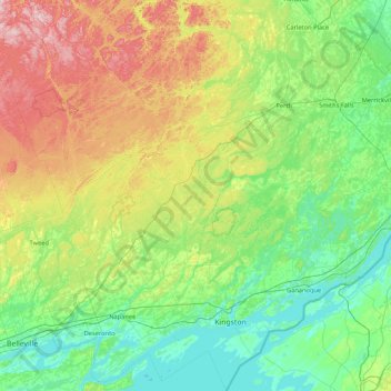
Name: Topografische Karte Frontenac County, Höhe, Relief.

Ort: Frontenac County, Eastern Ontario, Ontario, Canada (44.01483 -77.22179 45.22195 -76.16181)

Durchschnittliche Höhe: 169 m

Minimale Höhe: 70 m

Maximale Höhe: 492 m

👉 Easily get elevation data in JSON, GeoTIFF and KML formats using Elevation API
Vielen Dank für die Unterstützung dieser Website ❤️
Spenden

Andere topografische Karten

Klicken Sie auf eine Karte, um ihre Topografie, ihre Höhe und ihr Relief anzuzeigen.

Toronto

Canada > Ontario > Toronto

Despite its deep ravines, Toronto is not remarkably hilly, but its elevation does increase steadily away from the lake. Elevation differences range from 76.5 metres (251 ft) above sea level at the Lake Ontario shore to 209 m (686 ft) ASL near the York University grounds in the city's north end at the…

Durchschnittliche Höhe: 113 m

Hamilton

Canada > Ontario > Hamilton

Durchschnittliche Höhe: 181 m

London

Canada > Ontario > London > London

London has a humid continental climate (Köppen Dfb), though due to its downwind location relative to Lake Huron and elevation changes across the city, it is virtually on the Dfa/Dfb (hot summer) boundary favouring the former climate zone to the southwest of the confluence of the South and North Thames Rivers,…

Durchschnittliche Höhe: 268 m

Windsor

Canada > Ontario > Windsor

Durchschnittliche Höhe: 185 m

Vielen Dank für die Unterstützung dieser Website ❤️
Spenden

Peterborough

Canada > Ontario > Peterborough

Peterborough's topography is largely defined by land formations created by the receding Wisconsian glaciers 10,000–15,000 years ago. The South End and Downtown portions of the City sit on what was the bottom of the glacial Lake Peterborough—part of a glacial spillway created when glacial meltwaters from…

Durchschnittliche Höhe: 235 m

Guelph

Canada > Ontario > Guelph

This region of Ontario has cold winters and warm, humid summers, falling into the Köppen climate classification Dfb zone, with moderately high rainfall and snowfall. It is generally a couple of degrees cooler than lower elevation regions on the Great Lakes shorelines, especially so in winter, the exception…

Durchschnittliche Höhe: 344 m

Kawartha Lakes

Canada > Ontario > Kawartha Lakes

Durchschnittliche Höhe: 269 m

Guelph Lake

Canada > Ontario > Guelph/Eramosa

Durchschnittliche Höhe: 350 m

Vielen Dank für die Unterstützung dieser Website ❤️
Spenden

Alliston

Canada > Ontario > Simcoe County

Durchschnittliche Höhe: 233 m

Grand Bend

Canada > Ontario > Lambton County > Lambton Shores

Durchschnittliche Höhe: 183 m

Stratford

Canada > Ontario > Stratford

Durchschnittliche Höhe: 356 m

St. Thomas

Canada > Ontario > St. Thomas

Durchschnittliche Höhe: 231 m

Vielen Dank für die Unterstützung dieser Website ❤️
Spenden

Port Perry

Canada > Ontario > Durham Region > Scugog

Durchschnittliche Höhe: 263 m

Port Carling

Canada > Ontario > Muskoka District > Muskoka Lakes Township

Durchschnittliche Höhe: 242 m

Centennial Park

Canada > Ontario > Toronto

Durchschnittliche Höhe: 151 m

Clear Lake

Canada > Ontario > Parry Sound District > Seguin Township

Durchschnittliche Höhe: 252 m

Vielen Dank für die Unterstützung dieser Website ❤️
Spenden

Thomasburg

Canada > Ontario > Hastings County > Tweed

Durchschnittliche Höhe: 160 m

Ganaraska River

Canada > Ontario > Northumberland County > Port Hope

Durchschnittliche Höhe: 173 m

Niagara Escarpment

Canada > Ontario

Durchschnittliche Höhe: 299 m

Foymount

Canada > Ontario > Renfrew County > Bonnechere Valley

The location is also popular for amateur astronomers given the high altitude and low levels of artificial light.

Durchschnittliche Höhe: 432 m

Vielen Dank für die Unterstützung dieser Website ❤️
Spenden

South Porcupine

Canada > Ontario > Cochrane District > Timmins

Durchschnittliche Höhe: 300 m

Niagara Escarpment

Canada > Ontario > Burlington

Durchschnittliche Höhe: 216 m

Fort Albany

Canada > Ontario > Cochrane District

Durchschnittliche Höhe: 9 m

Vielen Dank für die Unterstützung dieser Website ❤️
Spenden

Bob's Lake

Canada > Ontario > Cochrane District > Timmins > Porcupine

Durchschnittliche Höhe: 287 m

Haliburton

Canada > Ontario

Durchschnittliche Höhe: 358 m

Sharbot Lake

Canada > Ontario > Frontenac County > Central Frontenac

Durchschnittliche Höhe: 201 m

Parry Sound

Canada > Ontario

Durchschnittliche Höhe: 235 m

Vielen Dank für die Unterstützung dieser Website ❤️
Spenden

Campbellford

Canada > Ontario > Northumberland County > Trent Hills

Durchschnittliche Höhe: 174 m

Speed River

Canada > Ontario > Guelph/Eramosa

Durchschnittliche Höhe: 352 m

Dundas

Canada > Ontario > Hamilton > Dundas

Dundas /ˈdʌnˌdæs/ is a community and former town in Hamilton, Ontario, Canada. It is nicknamed the Valley Town because of its topographical location at the bottom of the Niagara Escarpment on the western edge of Lake Ontario. The population has been stable for decades at about twenty thousand, largely…

Durchschnittliche Höhe: 171 m

Vielen Dank für die Unterstützung dieser Website ❤️
Spenden

Night Hawk Lake

Canada > Ontario > Timmins

Durchschnittliche Höhe: 275 m

Kelso Conservation Area

Canada > Ontario > Milton

Durchschnittliche Höhe: 279 m

Dunlop Lake

Canada > Ontario > Elliot Lake

Durchschnittliche Höhe: 379 m

Vielen Dank für die Unterstützung dieser Website ❤️
Spenden

New Liskeard

Canada > Ontario > Timiskaming District > Temiskaming Shores

Durchschnittliche Höhe: 212 m

Combermere

Canada > Ontario > Renfrew County > Madawaska Valley

Durchschnittliche Höhe: 318 m

Lucan

Canada > Ontario > Middlesex County > Lucan Biddulph

Durchschnittliche Höhe: 301 m

Millbrook

Canada > Ontario > Peterborough County > Cavan-Monaghan

Peterborough's topography is largely defined by land formations created by the receding Wisconsian glaciers 10,000–15,000 years ago. The South End and Downtown portions of the city sit on what was the bottom of the glacial Lake Peterborough—part of a glacial spillway created when glacial meltwaters from…

Durchschnittliche Höhe: 250 m

Vielen Dank für die Unterstützung dieser Website ❤️
Spenden

Mannheim

Canada > Ontario > Region of Waterloo > Wilmot > Mannheim

Durchschnittliche Höhe: 358 m

Chapleau

Canada > Ontario > Sudbury District > Chapleau Township

Durchschnittliche Höhe: 444 m

Huron Natural Area

Canada > Ontario > Region of Waterloo > Kitchener

Durchschnittliche Höhe: 338 m

Vielen Dank für die Unterstützung dieser Website ❤️
Spenden

Grassy Narrows

Canada > Ontario > Kenora District

Durchschnittliche Höhe: 327 m

Nobleton

Canada > Ontario > York Region > King

Durchschnittliche Höhe: 264 m

Vielen Dank für die Unterstützung dieser Website ❤️
Spenden

Newboro

Canada > Ontario > Leeds and Grenville Counties > Rideau Lakes

Durchschnittliche Höhe: 127 m

Brantford

Canada > Ontario > Brantford

Durchschnittliche Höhe: 238 m

Kenora

Canada > Ontario

Durchschnittliche Höhe: 182 m

Prince Edward

Canada > Ontario

Durchschnittliche Höhe: 118 m

Vielen Dank für die Unterstützung dieser Website ❤️
Spenden

Perth

Canada > Ontario

Durchschnittliche Höhe: 313 m

Lambton

Canada > Ontario

Durchschnittliche Höhe: 188 m

Essex

Canada > Ontario

Durchschnittliche Höhe: 193 m

Lac Seul

Canada > Ontario

Durchschnittliche Höhe: 365 m

Vielen Dank für die Unterstützung dieser Website ❤️
Spenden

Harlem Shoal

Canada > Ontario

Durchschnittliche Höhe: 175 m

St. Johns

Canada > Ontario

Durchschnittliche Höhe: 205 m

Almonte

Canada > Ontario > Lanark County > Mississippi Mills

Durchschnittliche Höhe: 137 m

Quetico Provincial Park

Canada > Ontario

Durchschnittliche Höhe: 432 m

Vielen Dank für die Unterstützung dieser Website ❤️
Spenden

Niagara Escarpment

Canada > Ontario > Hamilton

Durchschnittliche Höhe: 162 m

Ohsweken

Canada > Ontario

Durchschnittliche Höhe: 208 m

Sagamok

Canada > Ontario

Durchschnittliche Höhe: 210 m

Pinehurst Lake

Canada > Ontario

Durchschnittliche Höhe: 295 m

Vielen Dank für die Unterstützung dieser Website ❤️
Spenden

Docker Lake

Canada > Ontario

Durchschnittliche Höhe: 377 m

Arden

Canada > Ontario > Frontenac County > Central Frontenac

Durchschnittliche Höhe: 200 m

Oneida Nation of the Thames

Canada > Ontario

Durchschnittliche Höhe: 224 m

Bigwin Island

Canada > Ontario

Durchschnittliche Höhe: 328 m

Vielen Dank für die Unterstützung dieser Website ❤️
Spenden

Wolseley Bay

Canada > Ontario > French River

Durchschnittliche Höhe: 198 m

Upper Pergeon Lake

Canada > Ontario

Durchschnittliche Höhe: 215 m

Larder Lake

Canada > Ontario > Timiskaming District > Larder Lake Township

Durchschnittliche Höhe: 300 m

York River

Canada > Ontario

Durchschnittliche Höhe: 397 m

Vielen Dank für die Unterstützung dieser Website ❤️
Spenden

Kawartha Lakes (city)

Canada > Ontario

Durchschnittliche Höhe: 274 m

Pelee Island

Canada > Ontario

Durchschnittliche Höhe: 173 m

Quinte West (city)

Canada > Ontario

Durchschnittliche Höhe: 160 m

Vielen Dank für die Unterstützung dieser Website ❤️
Spenden

London

Canada > Ontario

London has a humid continental climate (Köppen Dfb), though due to its downwind location relative to Lake Huron and elevation changes across the city, it is virtually on the Dfa/Dfb (hot summer) boundary favouring the former climate zone to the southwest of the confluence of the South and North Thames Rivers,…

Durchschnittliche Höhe: 269 m

Lambton

Canada > Ontario

Durchschnittliche Höhe: 191 m

Algoma District

Canada > Ontario

Durchschnittliche Höhe: 360 m

London (city)

Canada > Ontario

Durchschnittliche Höhe: 239 m

Vielen Dank für die Unterstützung dieser Website ❤️
Spenden

Kingston

Canada > Ontario > Kingston

Durchschnittliche Höhe: 94 m

French River

Canada > Ontario > Sudbury District

Durchschnittliche Höhe: 208 m

Oba

Canada > Ontario > Algoma District > Unorganized North Algoma

Durchschnittliche Höhe: 331 m

Vielen Dank für die Unterstützung dieser Website ❤️
Spenden

Bowmanville

Canada > Ontario > Bowmanville

Durchschnittliche Höhe: 108 m

Dorset

Canada > Ontario > Muskoka District

Durchschnittliche Höhe: 353 m

Westport

Canada > Ontario > Leeds and Grenville Counties

Durchschnittliche Höhe: 146 m

Port Dover

Canada > Ontario > Norfolk County

Durchschnittliche Höhe: 187 m

Vielen Dank für die Unterstützung dieser Website ❤️
Spenden

Elora

Canada > Ontario > Wellington County > Centre Wellington

Durchschnittliche Höhe: 395 m

Rouge National Urban Park

Canada > Ontario > Toronto

Durchschnittliche Höhe: 143 m

Don River

Canada > Ontario > Toronto

Durchschnittliche Höhe: 124 m

Georgetown

Canada > Ontario > Halton Region

Durchschnittliche Höhe: 255 m

Vielen Dank für die Unterstützung dieser Website ❤️
Spenden

Stoney Creek

Canada > Ontario > Hamilton > Stoney Creek

Durchschnittliche Höhe: 135 m

Madawaska River

Canada > Ontario > McNab/Braeside

Durchschnittliche Höhe: 176 m

Shawanaga Lake

Canada > Ontario > Parry Sound District > Whitestone

Durchschnittliche Höhe: 256 m

Scugog Lake

Canada > Ontario > Bruce County

Durchschnittliche Höhe: 181 m

Vielen Dank für die Unterstützung dieser Website ❤️
Spenden

Otter Lake

Canada > Ontario > Seguin

Durchschnittliche Höhe: 223 m

Paris

Canada > Ontario > Brant County

Durchschnittliche Höhe: 258 m

River Canard

Canada > Ontario > Essex County > Amherstburg

Durchschnittliche Höhe: 177 m

Norcan Lake

Canada > Ontario > Frontenac County > North Frontenac

Durchschnittliche Höhe: 229 m

Vielen Dank für die Unterstützung dieser Website ❤️
Spenden