
Topografische Karte Cedar Hill
Interaktive Karte
Klicken Sie auf die Karte, um die Höhe anzuzeigen.
Über diese Karte
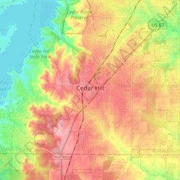
Name: Topografische Karte Cedar Hill, Höhe, Relief.
Ort: Cedar Hill, Dallas County, Texas, 75104, United States (32.53492 -97.02123 32.63941 -96.89043)
Durchschnittliche Höhe: 214 m
Minimale Höhe: 156 m
Maximale Höhe: 268 m
The city is sometimes referred to as the "hill country of Dallas" (in comparison to the "hill country" surrounding Austin and San Antonio). The city is full of native eastern red cedar evergreen trees and stands at an elevation of about 800 feet (240 m) above sea level—the highest point in a straight line from the Red River at the Texas-Oklahoma border to the Gulf Coast.
Andere topografische Karten
Klicken Sie auf eine Karte, um ihre Topografie, ihre Höhe und ihr Relief anzuzeigen.
Dallas
United States > Texas > Dallas County
Dallas, Dallas County, Texas, United States
Durchschnittliche Höhe: 160 m
Kenwood
United States > Texas > Dallas County > Dallas
Kenwood, Dallas, Dallas County, Texas, 75233, United States
Durchschnittliche Höhe: 199 m
Irving
United States > Texas > Dallas County
Irving, Dallas County, Texas, United States
Durchschnittliche Höhe: 149 m
Richardson
United States > Texas > Dallas County
Richardson, Dallas County, Texas, United States
Durchschnittliche Höhe: 191 m
Lancaster
United States > Texas > Dallas County
Lancaster, Dallas County, Texas, United States
Durchschnittliche Höhe: 165 m
Wilmer
United States > Texas > Dallas County
Wilmer, Dallas County, Texas, 75172, United States
Durchschnittliche Höhe: 140 m
Rowlett
United States > Texas > Dallas County
Rowlett, Dallas County, Texas, United States
Durchschnittliche Höhe: 147 m
Klyde Warren Park-Arts District PID
United States > Texas > Dallas County > Dallas
Klyde Warren Park-Arts District PID, Dallas, Dallas County, Texas, 75201, United States
Durchschnittliche Höhe: 143 m
Balch Springs
United States > Texas > Dallas County
Balch Springs, Dallas County, Texas, United States
Durchschnittliche Höhe: 147 m
Klyde Warren Park
United States > Texas > Dallas County > Dallas
Klyde Warren Park, Klyde Warren Park-Arts District PID, Dallas, Dallas County, Texas, 75201, United States
Durchschnittliche Höhe: 142 m
University Park
United States > Texas > Dallas County
University Park, Dallas County, Texas, United States
Durchschnittliche Höhe: 179 m
Grand Prairie
United States > Texas > Dallas County
Grand Prairie, Dallas County, Texas, United States
Durchschnittliche Höhe: 181 m
Seagoville
United States > Texas > Dallas County > Seagoville
Seagoville, Dallas County, Texas, 75159, United States
Durchschnittliche Höhe: 122 m
Dallas
United States > Texas > Dallas County > Dallas
Dallas, Dallas County, Texas, 75242, United States
Durchschnittliche Höhe: 158 m
Sunnyvale
United States > Texas > Dallas County > Sunnyvale
Sunnyvale, Dallas County, Texas, 75182, United States
Durchschnittliche Höhe: 142 m
Irving
United States > Texas > Dallas County > Irving
Irving, Dallas County, Texas, 75061, United States
Durchschnittliche Höhe: 162 m
Grand Prairie
United States > Texas > Dallas County > Grand Prairie
Grand Prairie, Dallas County, Texas, 75051, United States
Durchschnittliche Höhe: 170 m
Pioneer Park
United States > Texas > Dallas County > Dallas
Pioneer Park, Downtown PID, Dallas, Dallas County, Texas, United States
Durchschnittliche Höhe: 135 m
Coppell
United States > Texas > Dallas County
Coppell, Dallas County, Texas, 75019, United States
Durchschnittliche Höhe: 160 m
Coppell
United States > Texas > Dallas County > Coppell
Coppell, Dallas County, Texas, 75019, United States
Durchschnittliche Höhe: 160 m
Mesquite
United States > Texas > Dallas County
Mesquite, Dallas County, Texas, United States
Durchschnittliche Höhe: 142 m
Garland
United States > Texas > Dallas County
Garland, Dallas County, Texas, United States
Durchschnittliche Höhe: 165 m