Topografische Karte Airedale
Klicken Sie auf die Karte, um die Höhe anzuzeigen.
Airedale
Airedale, in conjunction with the Ribble Valley, provides low-altitude passes from Yorkshire to Lancashire through the Aire Gap. It is therefore an important transport route and was a strategically important area historically.
Über diese Karte
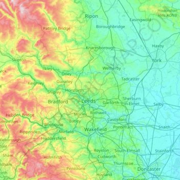
Name: Topografische Karte Airedale, Höhe, Relief.
Durchschnittliche Höhe: 60 m
Minimale Höhe: -1 m
Maximale Höhe: 375 m
Andere topografische Karten
Klicken Sie auf eine Karte, um ihre Topografie, ihre Höhe und ihr Relief anzuzeigen.

Walkington
United Kingdom > England > East Riding of Yorkshire > Walkington
Durchschnittliche Höhe: 76 m
Raywell
United Kingdom > England > East Riding of Yorkshire > Hull > West Ella
Durchschnittliche Höhe: 77 m

High Hunsley
United Kingdom > England > East Riding of Yorkshire > Rowley
Durchschnittliche Höhe: 135 m

Little Driffield
United Kingdom > England > East Riding of Yorkshire > Driffield
Durchschnittliche Höhe: 30 m
South Cave
United Kingdom > England > East Riding of Yorkshire > South Cave
Durchschnittliche Höhe: 38 m
River Hull
United Kingdom > England > East Riding of Yorkshire > Brandesburton
Durchschnittliche Höhe: 28 m




Market Weighton
United Kingdom > England > East Riding of Yorkshire > Market Weighton
Durchschnittliche Höhe: 43 m





East Cottingwith
United Kingdom > England > East Riding of Yorkshire > East Cottingwith
Durchschnittliche Höhe: 8 m


Withernsea
United Kingdom > England > East Riding of Yorkshire > Withernsea
Durchschnittliche Höhe: 5 m
Kelleythorpe
United Kingdom > England > East Riding of Yorkshire > Driffield
Durchschnittliche Höhe: 20 m
Stamford Bridge
United Kingdom > England > East Riding of Yorkshire > Stamford Bridge
Durchschnittliche Höhe: 16 m