
Spenden
Topografische Karte Crich CP
Klicken Sie auf die Karte, um die Höhe anzuzeigen.
Spenden
Crich CP
The memorial tower ('Crich Stand') was completed in 1923 as a memorial to the 11,409 soldiers from the Sherwood Foresters Regiment who died in World War I, a dedication that was later extended to include World War II. It was built on an limestone outcrop above the village, at an altitude of 1,000 feet (300 m) above sea level. The location is symbolic because it is widely visible across, and gives views of, both of the two counties from which the regiment was raised (Nottinghamshire and Derbyshire). It is the destination of an annual pilgrimage on the first Sunday in July.
Spenden
Über diese Karte
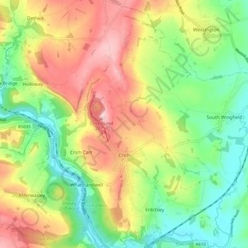
Name: Topografische Karte Crich CP, Höhe, Relief.
Ort: Crich CP, Amber Valley, Derbyshire, England, United Kingdom (53.06365 -1.50982 53.12288 -1.45672)
Durchschnittliche Höhe: 159 m
Minimale Höhe: 67 m
Maximale Höhe: 278 m
Spenden
Andere topografische Karten
Klicken Sie auf eine Karte, um ihre Topografie, ihre Höhe und ihr Relief anzuzeigen.
Alfreton Park
United Kingdom > England > Derbyshire > Amber Valley > Alfreton CP > Oakerthorpe
Durchschnittliche Höhe: 116 m
Sawmills
United Kingdom > England > Derbyshire > Amber Valley > Ripley > Fritchley
Durchschnittliche Höhe: 119 m
Spenden