
Topografische Karte Town of Lowville
Interaktive Karte
Klicken Sie auf die Karte, um die Höhe anzuzeigen.
Über diese Karte
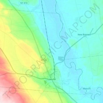
Name: Topografische Karte Town of Lowville, Höhe, Relief.
Durchschnittliche Höhe: 289 m
Minimale Höhe: 217 m
Maximale Höhe: 537 m
Lowville /ˈlaʊvɪl/ is a town in Lewis County, New York, United States. The population was 4,888 at the 2020 census, down from 4,982 in 2010. The town is near the center of the county and is southeast of the city of Watertown. The town of Lowville contains a village also named Lowville, which is the county seat. The town is named after Nicholas Low, an early landowner. Low was of Dutch descent, and had emigrated with his wife and three small children from a rural village outside Amsterdam in 1778. Despite popular folk etymology, the name Lowville has nothing to do with its low elevation or the lowing cattle of the many nearby dairy farms.
Andere topografische Karten
Klicken Sie auf eine Karte, um ihre Topografie, ihre Höhe und ihr Relief anzuzeigen.
Harrisville
United States > New York > Lewis County
Harrisville, Town of Diana, Lewis County, New York, United States
Durchschnittliche Höhe: 250 m
Brantingham Lake
United States > New York > Lewis County > Town of Greig
Brantingham Lake, Town of Greig, Lewis County, New York, 13312, United States
Durchschnittliche Höhe: 384 m
Village of Lyons Falls
United States > New York > Lewis County
Village of Lyons Falls, Town of West Turin, Lewis County, New York, United States
Durchschnittliche Höhe: 268 m
Town of West Turin
United States > New York > Lewis County
Town of West Turin, Lewis County, New York, 13325, United States
Durchschnittliche Höhe: 501 m
Town of New Bremen
United States > New York > Lewis County
Town of New Bremen, Lewis County, New York, United States
Durchschnittliche Höhe: 282 m
Beaver River
United States > New York > Lewis County > Town of Croghan > Village of Croghan
Beaver River, Village of Croghan, Town of Croghan, Lewis County, New York, 13305, United States
Durchschnittliche Höhe: 256 m
Village of Castorland
United States > New York > Lewis County > Town of Denmark
Village of Castorland, Town of Denmark, Lewis County, New York, United States
Durchschnittliche Höhe: 233 m
Town of Leyden
United States > New York > Lewis County
Town of Leyden, Lewis County, New York, United States
Durchschnittliche Höhe: 397 m
Town of Lewis
United States > New York > Lewis County
Town of Lewis, Lewis County, New York, 13489, United States
Durchschnittliche Höhe: 458 m
Montague
United States > New York > Lewis County
Montague, Lewis County, New York, United States
Durchschnittliche Höhe: 470 m
Town of Pinckney
United States > New York > Lewis County
Town of Pinckney, Lewis County, New York, 13626, United States
Durchschnittliche Höhe: 441 m
Beartown State Forest
United States > New York > Lewis County > Town of Croghan
Beartown State Forest, Town of Croghan, Town of Wilna, Lewis County, New York, United States
Durchschnittliche Höhe: 268 m
Brantingham
United States > New York > Lewis County > Brantingham
Brantingham, Greig, Lewis County, New York, 13345, United States
Durchschnittliche Höhe: 381 m
Belfort
United States > New York > Lewis County > Belfort
Belfort, Lewis County, New York, 13327, United States
Durchschnittliche Höhe: 312 m
Boonville Forest Preserve Detached Parcel
United States > New York > Lewis County
Boonville Forest Preserve Detached Parcel, Town of Boonville, Lewis County, New York, United States
Durchschnittliche Höhe: 355 m
Pleasant Lake
United States > New York > Lewis County > Brantingham
Pleasant Lake, Brantingham, Lewis County, New York, United States
Durchschnittliche Höhe: 384 m
Village of Lowville
United States > New York > Lewis County
Village of Lowville, Town of Lowville, Lewis County, New York, United States
Durchschnittliche Höhe: 285 m