
Spenden
Topografische Karte Les Ulis
Klicken Sie auf die Karte, um die Höhe anzuzeigen.
Spenden
Les Ulis
The source of the minor river Rouillon (river) is in the neighbouring town of Villejust, close to the communal border. The lowest point of the town, at the point where it meets Bures-sur-Yvette, is at an altitude of 87m. Most of the town is situated at an average altitude of over 150m. Its highest point is at 170m. The land on which it is built consists of clay, sand and millstone.
Spenden
Über diese Karte
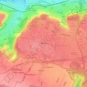
Name: Topografische Karte Les Ulis, Höhe, Relief.
Durchschnittliche Höhe: 138 m
Minimale Höhe: 60 m
Maximale Höhe: 174 m
Spenden
Andere topografische Karten
Klicken Sie auf eine Karte, um ihre Topografie, ihre Höhe und ihr Relief anzuzeigen.
Paris Basin
France > Ile-de-France > Essonne > Bièvres
The landscape is one of very broad valleys (flood plains), modest watershed hills and well-drained plateaux of comparatively little altitude. In the south-east and east the plain of Champagne and the Seuil de Bourgogne (Threshold of Burgundy) differential erosion of the strata has left low scarps with the dip…
Durchschnittliche Höhe: 126 m