Geolokalisieren
👉 Easily get elevation data in JSON, GeoTIFF and KML formats using Elevation API
Vielen Dank für die Unterstützung dieser Website ❤️
Spenden

Topografische Karte Tung Fort

Klicken Sie auf die Karte, um die Höhe anzuzeigen.

👉 Easily get elevation data in JSON, GeoTIFF and KML formats using Elevation API
Vielen Dank für die Unterstützung dieser Website ❤️
Spenden

Über diese Karte

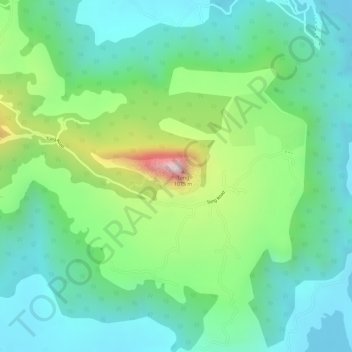
Name: Topografische Karte Tung Fort, Höhe, Relief.

Ort: Tung Fort, Mawal, Pune District, Maharashtra, India (18.65804 73.45785 18.66097 73.46506)

Durchschnittliche Höhe: 733 m

Minimale Höhe: 604 m

Maximale Höhe: 1.025 m

👉 Easily get elevation data in JSON, GeoTIFF and KML formats using Elevation API
Vielen Dank für die Unterstützung dieser Website ❤️
Spenden

Andere topografische Karten

Klicken Sie auf eine Karte, um ihre Topografie, ihre Höhe und ihr Relief anzuzeigen.

Lonavala

India > Maharashtra > Mawal

Adjacent to the Lohagad fort lies the visapur fort which is part of the Lohagad-Visapur fortification. Visapur Fort is larger and at a higher elevation than its twin- Lohagad. It was built during 1713-1720 CE by Balaji Vishwanath.

Durchschnittliche Höhe: 613 m

Talegaon Dabhade

India > Maharashtra > Mawal

Talegaon Dabhade has an altitude of 672 meters from sea level (2200 Ft), and thus enjoys pleasant weather round the year. Situated on the laps of Sahyadri mountain ranges, during monsoon rains, Talegaon Dabhade witnesses heavy rainfall adding to its overall natural beauty. Indrayani River, which originates in…

Durchschnittliche Höhe: 616 m

Parandawadi

India > Maharashtra > Mawal

Durchschnittliche Höhe: 606 m

Nanoli

India > Maharashtra > Mawal

Durchschnittliche Höhe: 655 m

Vielen Dank für die Unterstützung dieser Website ❤️
Spenden

Tungarli

India > Maharashtra > Mawal

Durchschnittliche Höhe: 630 m

Kambre

India > Maharashtra > Mawal

Durchschnittliche Höhe: 786 m

Chandkhed

India > Maharashtra > Mawal

Durchschnittliche Höhe: 619 m

Tikona Peth

India > Maharashtra > Mawal

Durchschnittliche Höhe: 676 m

Vielen Dank für die Unterstützung dieser Website ❤️
Spenden

Visapur Fort

India > Maharashtra > Mawal > Patan

Durchschnittliche Höhe: 818 m

Rajmachi Fort

India > Maharashtra > Mawal > Udhewadi

Durchschnittliche Höhe: 501 m

Shrivardhan Fort

India > Maharashtra > Mawal > Rajmachi village > Vanati Kakurwardi

Durchschnittliche Höhe: 533 m

Urse

India > Maharashtra > Mawal

Durchschnittliche Höhe: 617 m

Vielen Dank für die Unterstützung dieser Website ❤️
Spenden

Somatane

India > Maharashtra > Mawal

Durchschnittliche Höhe: 609 m

Lohagad Fort

India > Maharashtra > Mawal > Malavli > Lohagadwadi

Durchschnittliche Höhe: 796 m

Inglun

India > Maharashtra > Mawal

Durchschnittliche Höhe: 763 m

Godumbre

India > Maharashtra > Mawal

Durchschnittliche Höhe: 587 m

Vielen Dank für die Unterstützung dieser Website ❤️
Spenden

Tiger Point

India > Maharashtra > Mawal > Lonavala

Durchschnittliche Höhe: 547 m

Kale Colony

India > Maharashtra > Mawal

Durchschnittliche Höhe: 628 m

Wadgaon

India > Maharashtra > Mawal

Durchschnittliche Höhe: 662 m

Shrivardhan

India > Maharashtra > Mawal > Rajmachi village

Durchschnittliche Höhe: 534 m

Vielen Dank für die Unterstützung dieser Website ❤️
Spenden

Nanoli

India > Maharashtra > Mawal

Durchschnittliche Höhe: 655 m

Talegaon Dabhade

India > Maharashtra > Mawal

Talegaon Dabhade has an altitude of 672 meters from sea level (2200 Ft), and thus enjoys pleasant weather round the year. Situated on the laps of Sahyadri mountain ranges, during monsoon rains, Talegaon Dabhade witnesses heavy rainfall adding to its overall natural beauty. Indrayani River, which originates in…

Durchschnittliche Höhe: 616 m

Aadhe Khurd

India > Maharashtra > Mawal

Durchschnittliche Höhe: 616 m

Lohagad Fort

India > Maharashtra > Mawal > Malavli > Lohagadwadi

Durchschnittliche Höhe: 796 m

Vielen Dank für die Unterstützung dieser Website ❤️
Spenden

Visapur

India > Maharashtra > Mawal > Malavli

It is located in Pune district, 5 to 6 km from Malavli Railway station out of which 3 km is steep road. It has an elevation of 1084 meters above sea level. It is built on the same plateau as Lohagad.

Durchschnittliche Höhe: 822 m

Tungarli

India > Maharashtra > Mawal

Durchschnittliche Höhe: 630 m

Kambre

India > Maharashtra > Mawal

Durchschnittliche Höhe: 786 m

Talegaon Dabhade

India > Maharashtra > Mawal

Talegaon Dabhade has an altitude of 672 meters from sea level (2200 Ft), and thus enjoys pleasant weather round the year. Situated on the laps of Sahyadri mountain ranges, during monsoon rains, Talegaon Dabhade witnesses heavy rainfall adding to its overall natural beauty. Indrayani River, which originates in…

Durchschnittliche Höhe: 616 m

Vielen Dank für die Unterstützung dieser Website ❤️
Spenden