
Topografische Karte Da Gama Dam
Interaktive Karte
Klicken Sie auf die Karte, um die Höhe anzuzeigen.
Über diese Karte
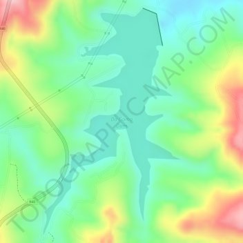
Name: Topografische Karte Da Gama Dam, Höhe, Relief.
Durchschnittliche Höhe: 912 m
Minimale Höhe: 839 m
Maximale Höhe: 1.032 m
Andere topografische Karten
Klicken Sie auf eine Karte, um ihre Topografie, ihre Höhe und ihr Relief anzuzeigen.
Crocodile River
RSA > Mpumalanga > Mbombela
Crocodile River, Mbombela, Ehlanzeni, Mpumalanga, RSA
Durchschnittliche Höhe: 1.042 m
Ngodwana Dam
RSA > Mpumalanga > Mbombela
Ngodwana Dam, Dam Inloop Pad, Mbombela Ward 12, Mbombela, Ehlanzeni, Mpumalanga, 1209, RSA
Durchschnittliche Höhe: 1.049 m
Mbombela Ward 12
RSA > Mpumalanga > Mbombela
Mbombela Ward 12, Mbombela, Ehlanzeni, Mpumalanga, 1209, RSA
Durchschnittliche Höhe: 1.142 m
Longmere Dam
RSA > Mpumalanga > Mbombela
Longmere Dam, R40, Mbombela Ward 3, Mbombela, Ehlanzeni, Mpumalanga, 1242, RSA
Durchschnittliche Höhe: 963 m
Mbombela Ward 17
RSA > Mpumalanga > Mbombela
Mbombela Ward 17, Mbombela, Ehlanzeni, Mpumalanga, 1201, RSA
Durchschnittliche Höhe: 788 m
Riet river
RSA > Mpumalanga > Mbombela
Riet river, Mbombela, Ehlanzeni, Mpumalanga, RSA
Durchschnittliche Höhe: 700 m
Mbombela Ward 16
RSA > Mpumalanga > Mbombela
Mbombela Ward 16, Mbombela, Ehlanzeni, Mpumalanga, 1212, RSA
Durchschnittliche Höhe: 890 m