
Vielen Dank für die Unterstützung dieser Website ❤️
Spenden
Spenden
Topografische Karte Dharasuram
Klicken Sie auf die Karte, um die Höhe anzuzeigen.
Vielen Dank für die Unterstützung dieser Website ❤️
Spenden
Spenden
Dharasuram
Airavateswara Temple faces problems of inundation after every downpour. Unimaginative municipal planning has resulted in the temple being at a lower elevation than the surrounding roads. This results in inundation during rains.
Vielen Dank für die Unterstützung dieser Website ❤️
Spenden
Spenden
Über diese Karte
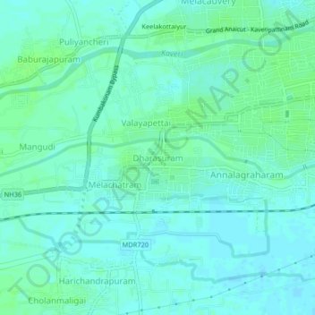
Name: Topografische Karte Dharasuram, Höhe, Relief.
Ort: Dharasuram, Kumbakonam, Thanjavur, Tamil Nadu, 612302, India (10.93137 79.33692 10.97137 79.37692)
Durchschnittliche Höhe: 28 m
Minimale Höhe: 24 m
Maximale Höhe: 33 m
Vielen Dank für die Unterstützung dieser Website ❤️
Spenden
Spenden