
Topografische Karte Guangzhou City
Interaktive Karte
Klicken Sie auf die Karte, um die Höhe anzuzeigen.
Guangzhou City
The elevation of the prefecture generally increases from southwest to northeast, with mountains forming the backbone of the city and the ocean comprising the front. Tiantang Peak (天堂顶, "Heavenly Peak") is the highest point of elevation at 1,210 metres (3,970 ft) above sea level.
Über diese Karte
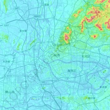
Name: Topografische Karte Guangzhou City, Höhe, Relief.
Durchschnittliche Höhe: 21 m
Minimale Höhe: -15 m
Maximale Höhe: 364 m