
Topografische Karte Donoughmore
Interaktive Karte
Klicken Sie auf die Karte, um die Höhe anzuzeigen.
Über diese Karte
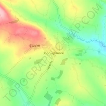
Name: Topografische Karte Donoughmore, Höhe, Relief.
Durchschnittliche Höhe: 183 m
Minimale Höhe: 119 m
Maximale Höhe: 272 m
Andere topografische Karten
Klicken Sie auf eine Karte, um ihre Topografie, ihre Höhe und ihr Relief anzuzeigen.
Kilnamartery
Ireland > County Cork > Municipal District of Macroom
Kilnamartery, Municipal District of Macroom, County Cork, Munster, Ireland
Durchschnittliche Höhe: 118 m
Iniscarra Dam View
Ireland > County Cork > Municipal District of Macroom
Iniscarra Dam View, L5228, Ovens, Municipal District of Macroom, County Cork, Munster, P31 TX39, Ireland
Durchschnittliche Höhe: 83 m
Monallig
Ireland > County Cork > Municipal District of Macroom
Monallig, Cannaway ED, Municipal District of Macroom, County Cork, Munster, Ireland
Durchschnittliche Höhe: 90 m
Drominahilla
Ireland > County Cork > Municipal District of Macroom
Drominahilla, Drishane, Municipal District of Macroom, County Cork, Munster, Ireland
Durchschnittliche Höhe: 127 m
Macroom
Ireland > County Cork > Municipal District of Macroom
Macroom, Municipal District of Macroom, County Cork, Munster, Ireland
Durchschnittliche Höhe: 210 m
Loughane East
Ireland > County Cork > Municipal District of Macroom
Loughane East, Matehy, Municipal District of Macroom, County Cork, Munster, Ireland
Durchschnittliche Höhe: 98 m