
Topografische Karte Bowman County
Interaktive Karte
Klicken Sie auf die Karte, um die Höhe anzuzeigen.
Über diese Karte
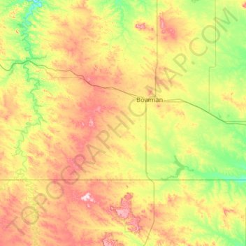
Name: Topografische Karte Bowman County, Höhe, Relief.
Ort: Bowman County, North Dakota, United States of America (45.94513 -104.04682 46.28085 -102.99556)
Durchschnittliche Höhe: 899 m
Minimale Höhe: 791 m
Maximale Höhe: 1.099 m
Andere topografische Karten
Klicken Sie auf eine Karte, um ihre Topografie, ihre Höhe und ihr Relief anzuzeigen.
Haynes
United States of America > North Dakota > Haynes > Haynes
Haynes, Adams County, North Dakota, United States of America
Durchschnittliche Höhe: 790 m
Hannah
United States of America > North Dakota > Hannah
Hannah, Cavalier County, North Dakota, United States of America
Durchschnittliche Höhe: 476 m
Barney
United States of America > North Dakota > Barney
Barney, Richland County, North Dakota, United States of America
Durchschnittliche Höhe: 316 m
Flaxton
United States of America > North Dakota > Flaxton > Flaxton
Flaxton, Burke County, North Dakota, United States of America
Durchschnittliche Höhe: 590 m
Avoca
United States of America > North Dakota > Avoca
Avoca, Williams County, North Dakota, United States of America
Durchschnittliche Höhe: 625 m
New England
United States of America > North Dakota > New England
New England, Hettinger County, North Dakota, 58647, United States of America
Durchschnittliche Höhe: 793 m
Buxton
United States of America > North Dakota > Buxton
Buxton, Traill County, North Dakota, United States of America
Durchschnittliche Höhe: 285 m
Billings County
United States of America > North Dakota
Billings County, North Dakota, United States of America
Durchschnittliche Höhe: 790 m
Leith
United States of America > North Dakota > Leith
Leith, Grant County, North Dakota, United States of America
Durchschnittliche Höhe: 714 m