Geolokalisieren
👉 Easily get elevation data in JSON, GeoTIFF and KML formats using Elevation API
Vielen Dank für die Unterstützung dieser Website ❤️
Spenden

Topografische Karte Chincoteague

Klicken Sie auf die Karte, um die Höhe anzuzeigen.

👉 Easily get elevation data in JSON, GeoTIFF and KML formats using Elevation API
Vielen Dank für die Unterstützung dieser Website ❤️
Spenden

Chincoteague

Chincoteague is located at 37°56′5″N 75°22′4″W / 37.93472°N 75.36778°W / 37.93472; -75.36778 (37.934673, −75.367805). According to the United States Census Bureau, the town has a total area of 37.3 square miles (96.7 km2), of which 9.1 square miles (23.6 km2) is land and 28.2 square miles (73.1 km2), or 75.58%, is water. It lies at an elevation of three feet.

Wikipedia (CC-BY-SA 3.0)

👉 Easily get elevation data in JSON, GeoTIFF and KML formats using Elevation API
Vielen Dank für die Unterstützung dieser Website ❤️
Spenden

Über diese Karte

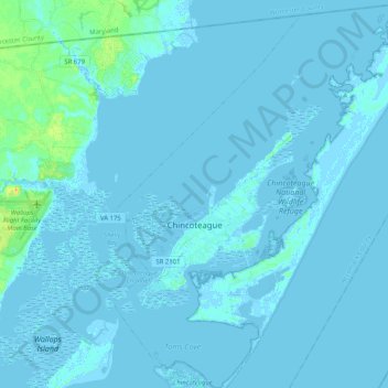
Name: Topografische Karte Chincoteague, Höhe, Relief.

Ort: Chincoteague, Accomack County, Virginia, 23336, United States (37.86544 -75.42230 38.02645 -75.25262)

Durchschnittliche Höhe: 1 m

Minimale Höhe: -5 m

Maximale Höhe: 24 m

👉 Easily get elevation data in JSON, GeoTIFF and KML formats using Elevation API
Vielen Dank für die Unterstützung dieser Website ❤️
Spenden

Andere topografische Karten

Klicken Sie auf eine Karte, um ihre Topografie, ihre Höhe und ihr Relief anzuzeigen.

Hacksneck

United States > Virginia > Accomack County

Durchschnittliche Höhe: 1 m

Birch Town

United States > Virginia > Accomack County > Chincoteague

Durchschnittliche Höhe: 1 m

Saxis Island

United States > Virginia > Accomack County > Saxis

Durchschnittliche Höhe: 2 m

Vielen Dank für die Unterstützung dieser Website ❤️
Spenden

Tangier Island

United States > Virginia > Accomack County > Tangier

Durchschnittliche Höhe: 2 m

Great Fox Island

United States > Virginia > Accomack County

Durchschnittliche Höhe: 0 m

Tangier Island

United States > Virginia > Accomack County > Tangier

Durchschnittliche Höhe: 2 m

Oak Hall

United States > Virginia > Accomack County

It lies at an elevation of 26 feet.

Durchschnittliche Höhe: 10 m

Vielen Dank für die Unterstützung dieser Website ❤️
Spenden

Assawoman Island

United States > Virginia > Accomack County

Durchschnittliche Höhe: 2 m

Deep Creek

United States > Virginia > Accomack County

Durchschnittliche Höhe: 1 m

Deep Creek

United States > Virginia > Accomack County

It lies at an elevation of 3 feet.

Durchschnittliche Höhe: 1 m

Upper Tump

United States > Virginia > Accomack County

Durchschnittliche Höhe: 0 m

Vielen Dank für die Unterstützung dieser Website ❤️
Spenden