
Topografische Karte Kowie River
Interaktive Karte
Klicken Sie auf die Karte, um die Höhe anzuzeigen.
Über diese Karte
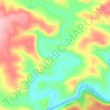
Name: Topografische Karte Kowie River, Höhe, Relief.
Durchschnittliche Höhe: 240 m
Minimale Höhe: 144 m
Maximale Höhe: 351 m
Andere topografische Karten
Klicken Sie auf eine Karte, um ihre Topografie, ihre Höhe und ihr Relief anzuzeigen.
Thomas Baines Nature Reserve
RSA > Eastern Cape > Makana Local Municipality
Thomas Baines Nature Reserve, R343, Makana Ward 13, Makana Local Municipality, Sarah Baartman District Municipality, Eastern Cape, RSA
Durchschnittliche Höhe: 373 m
Shamwari Private Game Reserve
RSA > Eastern Cape > Makana Local Municipality
Shamwari Private Game Reserve, Makana Ward 14, Makana Local Municipality, Sarah Baartman District Municipality, Eastern Cape, RSA
Durchschnittliche Höhe: 356 m
Coleridge Game Reserve
RSA > Eastern Cape > Makana Local Municipality
Coleridge Game Reserve, R67, Makana Ward 13, Makana Local Municipality, Sarah Baartman District Municipality, Eastern Cape, 6139, RSA
Durchschnittliche Höhe: 392 m
Makana Ward 6
RSA > Eastern Cape > Makana Local Municipality
Makana Ward 6, Makana Local Municipality, Sarah Baartman District Municipality, Eastern Cape, RSA
Durchschnittliche Höhe: 637 m