
Spenden
Topografische Karte Udhagamandalam
Klicken Sie auf die Karte, um die Höhe anzuzeigen.
Spenden
Udhagamandalam
Ooty is situated in the Nilgiri Biosphere Reserve. Many of the forested areas and water bodies are off-limits to most visitors in order to protect this fragile ecosystem. Some areas of the Biosphere Reserve have been earmarked for tourism development, and steps are being undertaken to open these areas to visitors whilst conserving the area. It is situated at an altitude of 2,240 metres (7,350 feet) above sea level.
Spenden
Über diese Karte
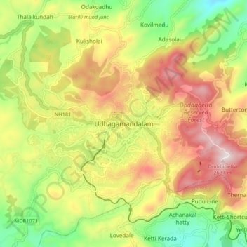
Name: Topografische Karte Udhagamandalam, Höhe, Relief.
Ort: Udhagamandalam, Nilgiris, Tamil Nadu, 643001, India (11.37268 76.66305 11.45268 76.74305)
Durchschnittliche Höhe: 2.234 m
Minimale Höhe: 1.881 m
Maximale Höhe: 2.622 m
Spenden
Andere topografische Karten
Klicken Sie auf eine Karte, um ihre Topografie, ihre Höhe und ihr Relief anzuzeigen.
Government Botanical Garden
India > Tamil Nadu > Udhagamandalam > Udhagamandalam
Durchschnittliche Höhe: 2.325 m