
Topografische Karte Meurthe-et-Moselle
Interaktive Karte
Klicken Sie auf die Karte, um die Höhe anzuzeigen.
Über diese Karte
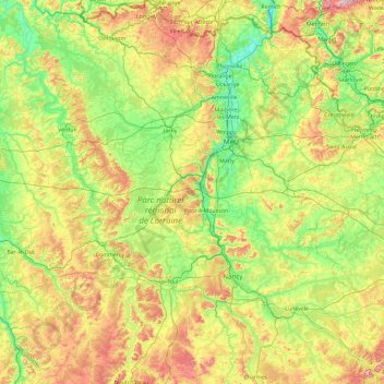
Name: Topografische Karte Meurthe-et-Moselle, Höhe, Relief.
Ort: Meurthe-et-Moselle, Grand Est, France métropolitaine, France (48.34890 5.42607 49.56334 7.12322)
Durchschnittliche Höhe: 275 m
Minimale Höhe: 141 m
Maximale Höhe: 614 m
Andere topografische Karten
Klicken Sie auf eine Karte, um ihre Topografie, ihre Höhe und ihr Relief anzuzeigen.
Nancy
France > Grand Est > Meurthe-et-Moselle
Nancy, Meurthe-et-Moselle, Grand Est, France métropolitaine, France
Durchschnittliche Höhe: 230 m
Thionville
Thionville, Moselle, Grand Est, France métropolitaine, 57100, France
Durchschnittliche Höhe: 190 m
Strasbourg
Strasbourg, Bas-Rhin, Grand Est, France métropolitaine, France
Durchschnittliche Höhe: 144 m
Haute-Marne
Haute-Marne, Grand Est, France métropolitaine, France
Durchschnittliche Höhe: 308 m
Vieux Marche
France > Grand Est > Ardennes > Château-Porcien
Vieux Marche, Château-Porcien, Rethel, Ardennes, Grand Est, France métropolitaine, 08360, France
Durchschnittliche Höhe: 89 m
Dombasle-devant-Darney
Dombasle-devant-Darney, Neufchâteau, Vosges, Grand Est, France métropolitaine, 88260, France
Durchschnittliche Höhe: 339 m
Faymont
France > Grand Est > Vosges > Le Val-d'Ajol
Faymont, Le Val-d'Ajol, Épinal, Vosges, Grand Est, France métropolitaine, 88340, France
Durchschnittliche Höhe: 533 m
Liffol-le-Grand
Liffol-le-Grand, Neufchâteau, Vosges, Grand Est, France métropolitaine, 88350, France
Durchschnittliche Höhe: 360 m
They-sous-Montfort
They-sous-Montfort, Neufchâteau, Vosges, Grand Est, France métropolitaine, 88800, France
Durchschnittliche Höhe: 396 m
Willer-sur-Thur
France > Grand Est > Haut-Rhin
Willer-sur-Thur, Thann-Guebwiller, Haut-Rhin, Grand Est, France métropolitaine, 68760, France
Durchschnittliche Höhe: 608 m
Vosges
France > Grand Est > Goldbach-Altenbach
Vosges, Goldbach-Altenbach, Thann-Guebwiller, Haut-Rhin, Grand Est, France métropolitaine, 68760, France
Durchschnittliche Höhe: 864 m
Éclaron-Braucourt-Sainte-Livière
France > Grand Est > Haute-Marne
Éclaron-Braucourt-Sainte-Livière, Saint-Dizier, Haute-Marne, Grand Est, France métropolitaine, 52290, France
Durchschnittliche Höhe: 144 m
Ham-les-Moines
Ham-les-Moines, Charleville-Mézières, Ardennes, Grand Est, France métropolitaine, 08090, France
Durchschnittliche Höhe: 162 m
Montagne de Langres
France > Grand Est > Haute-Marne > Saint-Ciergues
Montagne de Langres, Saint-Ciergues, Langres, Haute-Marne, Grand Est, France métropolitaine, 52200, France
Durchschnittliche Höhe: 398 m
Tellancourt
France > Grand Est > Meurthe-et-Moselle
Tellancourt, Val-de-Briey, Meurthe-et-Moselle, Grand Est, France métropolitaine, 54260, France
Durchschnittliche Höhe: 375 m
Ugny
France > Grand Est > Meurthe-et-Moselle
Ugny, Val-de-Briey, Meurthe-et-Moselle, Grand Est, France métropolitaine, 54870, France
Durchschnittliche Höhe: 306 m
Mainvillers
Mainvillers, Forbach-Boulay-Moselle, Moselle, Grand Est, France métropolitaine, 57380, France
Durchschnittliche Höhe: 270 m
Saint-Dié-des-Vosges
Saint-Dié-des-Vosges, Vosges, Grand Est, France métropolitaine, 88100, France
Durchschnittliche Höhe: 433 m
Rupt-en-Woëvre
Rupt-en-Woëvre, Verdun, Meuse, Grand Est, France métropolitaine, 55320, France
Durchschnittliche Höhe: 309 m
Seraucourt
France > Grand Est > Meuse > Beausite
Seraucourt, Beausite, Bar-le-Duc, Meuse, Grand Est, France métropolitaine, 55250, France
Durchschnittliche Höhe: 276 m
Étang Gerig
France > Grand Est > Bas-Rhin > Ostwald
Étang Gerig, Ostwald, Strasbourg, Bas-Rhin, Grand Est, France métropolitaine, 67540, France
Durchschnittliche Höhe: 142 m
Saint-Firmin
France > Grand Est > Meurthe-et-Moselle
Saint-Firmin, Nancy, Meurthe-et-Moselle, Grand Est, France métropolitaine, 54930, France
Durchschnittliche Höhe: 296 m
Maizières
France > Grand Est > Meurthe-et-Moselle
Maizières, Nancy, Meurthe-et-Moselle, Grand Est, France métropolitaine, 54550, France
Durchschnittliche Höhe: 288 m
Allain
France > Grand Est > Meurthe-et-Moselle
Allain, Toul, Meurthe-et-Moselle, Grand Est, France métropolitaine, 54170, France
Durchschnittliche Höhe: 312 m
Loutzviller
Loutzviller, Sarreguemines, Moselle, Grand Est, France métropolitaine, 57720, France
Durchschnittliche Höhe: 308 m
Saint-Jean-Saverne
Saint-Jean-Saverne, Saverne, Bas-Rhin, Grand Est, France métropolitaine, 67700, France
Durchschnittliche Höhe: 272 m
Montcy-Notre-Dame
Montcy-Notre-Dame, Charleville-Mézières, Ardennes, Grand Est, France métropolitaine, 08090, France
Durchschnittliche Höhe: 205 m