
Topografische Karte Zaragoza
Klicken Sie auf die Karte, um die Höhe anzuzeigen.
Zaragoza
On 1 January 2019 the population of the city of Zaragoza was 706,904, within its administrative limits on a land area of 1,062.64 square kilometres (410.29 square miles), ranking fifth in Spain. It is the 32nd most populous municipality in the European Union. The population of the metropolitan area was estimated in 2006 at 783,763 inhabitants. The municipality is home to more than 50 percent of the Aragonese population. The city lies at an elevation of 199 metres (653 feet) above sea level.
Über diese Karte
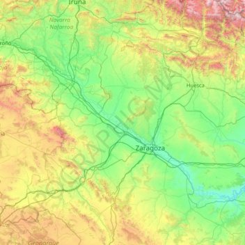
Name: Topografische Karte Zaragoza, Höhe, Relief.
Ort: Zaragoza, Aragon, Spain (40.93622 -2.17367 42.74413 0.38566)
Durchschnittliche Höhe: 701 m
Minimale Höhe: 110 m
Maximale Höhe: 3.187 m
Andere topografische Karten
Klicken Sie auf eine Karte, um ihre Topografie, ihre Höhe und ihr Relief anzuzeigen.
Santa Eulalia la Mayor
Spain > Aragon > Hoya de Huesca / Plana de Uesca > Loporzano
Durchschnittliche Höhe: 790 m
Santa María de la Peña
Spain > Aragon > Hoya de Huesca / Plana de Uesca > Las Peñas de Riglos
Durchschnittliche Höhe: 682 m
Sistema Ibérico
Spain > Aragon > Tarazona y el Moncayo > Tarazona
The geology of the Iberian System is complex, for it can hardly be defined as a homogeneous system. It is composed of a haphazard and motley series of mountain ranges, massifs, plateaus and depressions without a definite common petrologic composition and overall structure. Nummulite limestone, marble and…
Durchschnittliche Höhe: 1.906 m
Riglos
Spain > Aragon > Hoya de Huesca / Plana de Uesca > Las Peñas de Riglos
Durchschnittliche Höhe: 726 m
"El Cerro la Silla" (Cima oeste)
Spain > Aragon > Campo de Cariñena > Cosuenda
Durchschnittliche Höhe: 954 m
Peña Foratata
Spain > Aragon > Hoya de Huesca / Plana de Uesca > Loporzano
Durchschnittliche Höhe: 1.059 m
Sosas
Spain > Aragon > Somontano de Barbastro > Hoz y Costeán > Hoz de Barbastro
Durchschnittliche Höhe: 601 m
"El Cerro la Silla" (Cima oeste)
Spain > Aragon > Campo de Cariñena > Cosuenda
Durchschnittliche Höhe: 954 m
Santa Magdalena
Spain > Aragon > Comunidad de Calatayud > Miedes de Aragón
Durchschnittliche Höhe: 834 m
Los Carneros
Spain > Aragon > Hoya de Huesca / Plana de Uesca > Loporzano
Durchschnittliche Höhe: 807 m
Marcuello
Spain > Aragon > Hoya de Huesca / Plana de Uesca > Loarre > Linás de Marcuello
Durchschnittliche Höhe: 863 m
Vitales
Spain > Aragon > Hoya de Huesca / Plana de Uesca > Monflorite-Lascasas
Durchschnittliche Höhe: 492 m
Pla de Beronia
Spain > Aragon > Bajo Aragón-Caspe / Baix Aragó-Casp > Fabara / Favara
Durchschnittliche Höhe: 215 m