
Topografische Karte Mogok
Interaktive Karte
Klicken Sie auf die Karte, um die Höhe anzuzeigen.
Mogok
At 1,170 metres (3,840 ft) in elevation, the city has a fairly temperate climate year-round, and is home to Bamar, Shan, Lisu, Palaung, and Karen ethnic groups, as well as Chinese, Indians and Gurkhas. The city is composed of two towns, Mogok and Kyat Pyin. Mogok is four miles long and two miles wide. It is situated in a valley surrounded by a large number of mountains. Kyatpyin lies about 7 miles (11 km) southwest of Mogok. Tourists that travel to this area need a special authorization and a guide person.
Über diese Karte
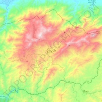
Name: Topografische Karte Mogok, Höhe, Relief.
Durchschnittliche Höhe: 993 m
Minimale Höhe: 173 m
Maximale Höhe: 2.227 m
Andere topografische Karten
Klicken Sie auf eine Karte, um ihre Topografie, ihre Höhe und ihr Relief anzuzeigen.