
Spenden
Topografische Karte Chendamangalam
Klicken Sie auf die Karte, um die Höhe anzuzeigen.
Spenden
Über diese Karte
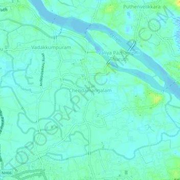
Name: Topografische Karte Chendamangalam, Höhe, Relief.
Ort: Chendamangalam, Paravur, Ernakulam, Kerala, 683512, India (10.14917 76.21409 10.18917 76.25409)
Durchschnittliche Höhe: 5 m
Minimale Höhe: -4 m
Maximale Höhe: 21 m
Spenden
Andere topografische Karten
Klicken Sie auf eine Karte, um ihre Topografie, ihre Höhe und ihr Relief anzuzeigen.
Spenden
periyar river
India > Kerala > Paravur > Manjaly
The southernmost part of the Cardamom Hills i.e. the source of Periyar River is a narrow valley extending south of Kumily. This is the southern extreme of the Periyar basin. It is less than 20 kilometres (12 mi) wide and is about 40 kilometres (25 mi) long. The upper catchments of Periyar extend as a wedge…
Durchschnittliche Höhe: 10 m
Periyar River
India > Kerala > Paravur > Edayar
The southernmost part of the Cardamom Hills i.e. the source of Periyar River is a narrow valley extending south of Kumily. This is the southern extreme of the Periyar basin. It is less than 20 kilometres (12 mi) wide and is about 40 kilometres (25 mi) long. The upper catchments of Periyar extend as a wedge…
Durchschnittliche Höhe: 8 m
Spenden