
Topografische Karte Milton
Interaktive Karte
Klicken Sie auf die Karte, um die Höhe anzuzeigen.
Über diese Karte
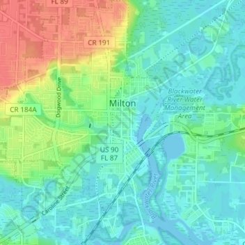
Name: Topografische Karte Milton, Höhe, Relief.
Ort: Milton, Santa Rosa County, Florida, 32572, United States (30.60225 -87.07743 30.65440 -87.02938)
Durchschnittliche Höhe: 15 m
Minimale Höhe: -3 m
Maximale Höhe: 51 m
Andere topografische Karten
Klicken Sie auf eine Karte, um ihre Topografie, ihre Höhe und ihr Relief anzuzeigen.
Navarre
United States > Florida > Santa Rosa County
Navarre, Santa Rosa County, Florida, 32566, United States
Durchschnittliche Höhe: 4 m
Gulf Breeze
United States > Florida > Santa Rosa County
Gulf Breeze, Santa Rosa County, Florida, United States
Durchschnittliche Höhe: 1 m
Milton
United States > Florida > Santa Rosa County > Milton > Milton
Milton, Santa Rosa County, Florida, 32572, United States
Durchschnittliche Höhe: 21 m