
Topografische Karte Waipa Stream
Interaktive Karte
Klicken Sie auf die Karte, um die Höhe anzuzeigen.
Über diese Karte
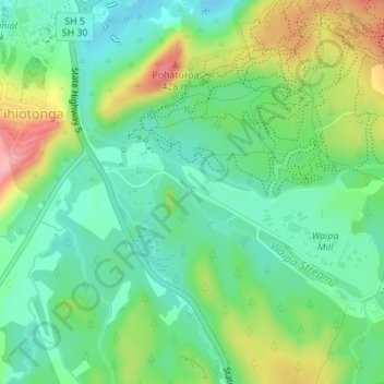
Name: Topografische Karte Waipa Stream, Höhe, Relief.
Durchschnittliche Höhe: 343 m
Minimale Höhe: 300 m
Maximale Höhe: 424 m
Andere topografische Karten
Klicken Sie auf eine Karte, um ihre Topografie, ihre Höhe und ihr Relief anzuzeigen.
Lake Rerewhakaaitu
New Zealand > Bay of Plenty > Rotorua
Lake Rerewhakaaitu, Rotorua, Bay of Plenty, New Zealand
Durchschnittliche Höhe: 440 m
Waikuta
New Zealand > Bay of Plenty > Rotorua > Ngongotaha > Waikuta
Waikuta, Ngongotaha, Rotorua, Bay of Plenty, 3015, New Zealand
Durchschnittliche Höhe: 324 m
Mokoia Island
New Zealand > Bay of Plenty > Rotorua
Mokoia Island, Rotorua, Rotorua District, Bay of Plenty, New Zealand
Durchschnittliche Höhe: 291 m
Kaituna River
New Zealand > Bay of Plenty > Rotorua
Kaituna River, Rotorua, Rotorua District, Bay of Plenty, New Zealand
Durchschnittliche Höhe: 228 m
Mount Tarawera
New Zealand > Bay of Plenty > Rotorua
Mount Tarawera, Rotorua, Rotorua District, Bay of Plenty, New Zealand
Durchschnittliche Höhe: 894 m
Tarawera River
New Zealand > Bay of Plenty > Rotorua
Tarawera River, Rotorua, Rotorua District, Bay of Plenty, New Zealand
Durchschnittliche Höhe: 194 m
Lake Rotongata
New Zealand > Bay of Plenty > Rotorua
Lake Rotongata, Kaharoa Road, Rotorua, Rotorua District, Bay of Plenty, 3096, New Zealand
Durchschnittliche Höhe: 340 m
Okere Falls
New Zealand > Bay of Plenty > Rotorua
Okere Falls, Rotorua, Rotorua District, Bay of Plenty, New Zealand
Durchschnittliche Höhe: 315 m
Lake Rotokawa
New Zealand > Bay of Plenty > Rotorua
Lake Rotokawa, Te Huaki Crescent, Eastgate Business Park, Hannahs Bay, Rotorua, Rotorua District, Bay of Plenty, 3042, New Zealand
Durchschnittliche Höhe: 306 m
Ngongotahā
New Zealand > Bay of Plenty > Rotorua
Ngongotahā, Rotorua, Bay of Plenty, 3015, New Zealand
Durchschnittliche Höhe: 515 m