
Spenden
Topografische Karte Tynemouth Creek
Klicken Sie auf die Karte, um die Höhe anzuzeigen.
Spenden
Über diese Karte
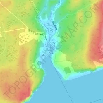
Name: Topografische Karte Tynemouth Creek, Höhe, Relief.
Durchschnittliche Höhe: 32 m
Minimale Höhe: -3 m
Maximale Höhe: 75 m
Spenden
Andere topografische Karten
Klicken Sie auf eine Karte, um ihre Topografie, ihre Höhe und ihr Relief anzuzeigen.
City of Saint John
Canada > New Brunswick > Saint John County
The topography surrounding Saint John is hilly; a result of the influence of two coastal mountain ranges which run along the Bay of Fundy – the St. Croix Highlands and the Caledonia Highlands. The soil throughout the region is extremely rocky with frequent granite outcrops. The coastal plain hosts numerous…
Durchschnittliche Höhe: 37 m
Treadwell Lake
Canada > New Brunswick > Saint John County > City of Saint John
Durchschnittliche Höhe: 104 m
Saint Martins Beach
Canada > New Brunswick > Saint John County > St. Martins
Durchschnittliche Höhe: 14 m
Spenden
Bains Corner
Canada > New Brunswick > Saint John County > Village of Fundy-St. Martins
Durchschnittliche Höhe: 88 m
City of Saint John
Canada > New Brunswick > Saint John County
The topography surrounding Saint John is hilly; a result of the influence of two coastal mountain ranges which run along the Bay of Fundy – the St. Croix Highlands and the Caledonia Highlands. The soil throughout the region is extremely rocky with frequent granite outcrops. The coastal plain hosts numerous…
Durchschnittliche Höhe: 37 m
City of Saint John
Canada > New Brunswick > Saint John County
The topography surrounding Saint John is hilly; a result of the influence of two coastal mountain ranges which run along the Bay of Fundy – the St. Croix Highlands and the Caledonia Highlands. The soil throughout the region is extremely rocky with frequent granite outcrops. The coastal plain hosts numerous…
Durchschnittliche Höhe: 36 m
Spenden
City of Saint John
Canada > New Brunswick > Saint John County
The topography surrounding Saint John is hilly; a result of the influence of two coastal mountain ranges which run along the Bay of Fundy – the St. Croix Highlands and the Caledonia Highlands. The soil throughout the region is extremely rocky with frequent granite outcrops. The coastal plain hosts numerous…
Durchschnittliche Höhe: 37 m