
Spenden
Topografische Karte Chesières
Klicken Sie auf die Karte, um die Höhe anzuzeigen.
Spenden
Über diese Karte
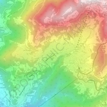
Name: Topografische Karte Chesières, Höhe, Relief.
Ort: Chesières, Ollon, District d'Aigle, Vaud, 1885, Switzerland (46.28129 7.02258 46.32129 7.06258)
Durchschnittliche Höhe: 1.247 m
Minimale Höhe: 652 m
Maximale Höhe: 1.921 m
Spenden
Andere topografische Karten
Klicken Sie auf eine Karte, um ihre Topografie, ihre Höhe und ihr Relief anzuzeigen.
Gryon
Switzerland > Vaud > District d'Aigle
The municipality is located in the Aigle district, on a narrow terrace at an elevation of 1,110 m (3,640 ft) between the Gryonne and Avançon canyons. To the east lie the hillside settlements of Les Chaux and La Barboleusaz (or Barboleuse). In the north are forests and the alpine pasture of Taveyanne. The…
Durchschnittliche Höhe: 1.240 m
Leysin
Switzerland > Vaud > District d'Aigle
The municipality is located in the Aigle district, on the right side of the Grande-Eau at the foot of the Tour d'Aï and the Tour de Mayen. The main village is located at an elevation of 1,260 m (4,130 ft). It consists of the village of Leysin and the hamlets of Veyges, Feydey, Aï, and Mayen.
Durchschnittliche Höhe: 1.352 m
Gryon
Switzerland > Vaud > District d'Aigle
The municipality is located in the Aigle district, on a narrow terrace at an elevation of 1,110 m (3,640 ft) between the Gryonne and Avançon canyons. The commune is composed of multiple settlements, which include the Gryon village, Barboleuse, Alpe des Chaux, Taveyanne, and Peuffeyre. In the western part…
Durchschnittliche Höhe: 1.240 m
Spenden
Spenden