
Topografische Karte Lake Chesdin
Interaktive Karte
Klicken Sie auf die Karte, um die Höhe anzuzeigen.
Über diese Karte
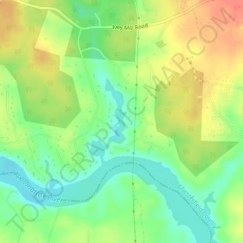
Name: Topografische Karte Lake Chesdin, Höhe, Relief.
Ort: Lake Chesdin, Chesterfield County, Virginia, United States (37.27076 -77.61980 37.28029 -77.61464)
Durchschnittliche Höhe: 63 m
Minimale Höhe: 38 m
Maximale Höhe: 91 m
Andere topografische Karten
Klicken Sie auf eine Karte, um ihre Topografie, ihre Höhe und ihr Relief anzuzeigen.
Beach
United States > Virginia > Chesterfield County
Beach, Chesterfield County, Virginia, 23838, United States
Durchschnittliche Höhe: 77 m
Woodlake
United States > Virginia > Chesterfield County
Woodlake, Chesterfield County, Virginia, 23112, United States
Durchschnittliche Höhe: 67 m
River Road Estates
United States > Virginia > Chesterfield County
River Road Estates, Chesterfield County, Virginia, 23806, United States
Durchschnittliche Höhe: 31 m
Summerford
United States > Virginia > Chesterfield County
Summerford, Chesterfield County, Virginia, United States
Durchschnittliche Höhe: 87 m
Kings Forest
United States > Virginia > Chesterfield County
Kings Forest, Chesterfield County, Virginia, 23234, United States
Durchschnittliche Höhe: 61 m
Chester
United States > Virginia > Chesterfield County > Chester
Chester, Chesterfield County, Virginia, 23831, United States
Durchschnittliche Höhe: 44 m
Leader
United States > Virginia > Chesterfield County
Leader, Chesterfield County, Virginia, United States
Durchschnittliche Höhe: 80 m
Presquile National Wildlife Refuge
United States > Virginia > Chesterfield County
Presquile National Wildlife Refuge, Chesterfield County, Virginia, United States
Durchschnittliche Höhe: 4 m
Pocahontas State Park
United States > Virginia > Chesterfield County
Pocahontas State Park, 10301, State Park Road, Chesterfield County, Virginia, 23832, United States
Durchschnittliche Höhe: 69 m
Five Forks
United States > Virginia > Chesterfield County
Five Forks, Chesterfield County, Virginia, 23832, United States
Durchschnittliche Höhe: 71 m
Midlothian
United States > Virginia > Chesterfield County
Midlothian, Chesterfield County, Virginia, 23113, United States
Durchschnittliche Höhe: 97 m
Grove Place
United States > Virginia > Chesterfield County > Grove Place
Grove Place, Chesterfield County, Virginia, 23831, United States
Durchschnittliche Höhe: 45 m
Nash Grove
United States > Virginia > Chesterfield County
Nash Grove, Chesterfield County, Virginia, 23838, United States
Durchschnittliche Höhe: 78 m
Bon Air
United States > Virginia > Chesterfield County > Bon Air
Bon Air, Chesterfield County, Virginia, United States
Durchschnittliche Höhe: 87 m
Brandermill
United States > Virginia > Chesterfield County
Brandermill, Chesterfield County, Virginia, 23112, United States
Durchschnittliche Höhe: 72 m
Hampton Park
United States > Virginia > Chesterfield County
Hampton Park, Chesterfield County, Virginia, 23120, United States
Durchschnittliche Höhe: 78 m