
Spenden
Topografische Karte Kamień
Klicken Sie auf die Karte, um die Höhe anzuzeigen.
Spenden
Über diese Karte
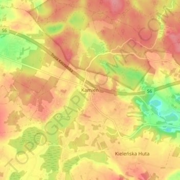
Name: Topografische Karte Kamień, Höhe, Relief.
Durchschnittliche Höhe: 199 m
Minimale Höhe: 144 m
Maximale Höhe: 230 m
Spenden
Andere topografische Karten
Klicken Sie auf eine Karte, um ihre Topografie, ihre Höhe und ihr Relief anzuzeigen.
Wejherowo
Poland > Pomeranian Voivodeship > Wejherowo County
Wejherowo is located in Pomeralia, in the ethnocultural region of Kashubia, approximately 11 km (7 mi) west of the town of Rumia, 32 kilometres (20 miles) east of the town of Lębork and 35 km (22 mi) north-west of the regional metropole of Gdańsk, in the broad glacial valley of the river Rheda at an altitude…
Durchschnittliche Höhe: 75 m
Wejherowo
Poland > Pomeranian Voivodeship > Wejherowo County > Wejherowo
Wejherowo is located in Pomeralia, in the ethnocultural region of Kashubia, approximately 11 km (7 mi) west of the town of Rumia, 32 kilometres (20 miles) east of the town of Lębork and 35 km (22 mi) north-west of the regional metropole of Gdańsk, in the broad glacial valley of the river Rheda at an altitude…
Durchschnittliche Höhe: 71 m
Spenden
Zbiornik Czymanowo
Poland > Pomeranian Voivodeship > Wejherowo County > Strzebielinek
Durchschnittliche Höhe: 94 m
Spenden
Spenden
Przetoczyno
Poland > Pomeranian Voivodeship > Wejherowo County > Przetoczyno
Durchschnittliche Höhe: 163 m
Spenden